A public park below its streets that drinks the storm, keeps water for the summer, purifies street water and holds the clay under houses
Third instalment of the Pacts series, after “The soil pacts” and “The air pact”. “Water: Reality and Solutions” newsletter, following on from the first two episodes published in “Oasis”. Yves Nicolas, functional ecology consultant, yvesnicolas.com.
The essentials for decision-makers
The first two episodes set out the pact and its three rules, then the 400 square metre module, the typical hectare, the palettes, the costs and the clauses. This one turns the park itself upside down.
The sunken park. A public park dug below its streets, with a pond on clay and no liner, drinks the storm from eight to eleven hectares of streets and roofs, keeps 1,300 cubic metres for the summer, purifies street water in seven stages before passing it on to the next park, and its reserve can supply, house by house, the upkeep of the clay under the neighbourhood’s foundations. It costs a quarter to half as much as a buried tank, and it is a nature reserve viewed from a belvedere, not a playground. Calculated for the volumes, demonstrated for purification, hypothesis for the clay.
The plan of this episode. Chapter 1 starts from the roundabout, as a cross and then as a basin, and arrives at the sunken park: the pond on clay without a liner, the vegetation, its use as a nature reserve, the purification of street water in seven stages, the volumes and rain durations, the cascade and the siphon, the precedents of Copenhagen, Rotterdam and Lyon, the cost, the valve and the two seasons. Chapter 2 sets out what the park brings the municipality, item by item, what it can do for the city’s clay, and what the reserve can do, house by house, with probe-controlled drip emitters, down to the country house with on-site sanitation. Chapter 3 gives the clauses. Each figure carries its level of certainty: established, debated, hypothesis, or my own calculation when I made it.
1. The cross roundabout, and the sunken park
If there is one place in the city where rule 2 applies by itself, it is the roundabout. Nobody walks there. Nobody picnics there. And yet it is mown, watered, and replanted with beds that motorists look at for three seconds. It is the showpiece of chapter 2 of the first episode in its purest form, and it is also the ideal site for a space left free.
This is how I design the mounded roundabout. In the centre, posts aligned along two perpendicular diameters draw a cross. Between them, nets or stainless steel cables are stretched, and climbers are planted. Within a few seasons, the cross becomes two green walls that intersect in the centre and divide the island into four separate spaces. This is where the idea becomes beautiful. Each of the four quarters faces a different point of the compass: one gets the midday sun, another the morning shade, a third the prevailing wind, the last the coolness of the north. The same mix is sown in each, and nature will make a different choice in each. After three years, the motorist driving round will see four natures born from the same seeds, and the sign at the entrance to the town can tell him so. I know of no clearer demonstration of what I call the direction given and the direction chosen.
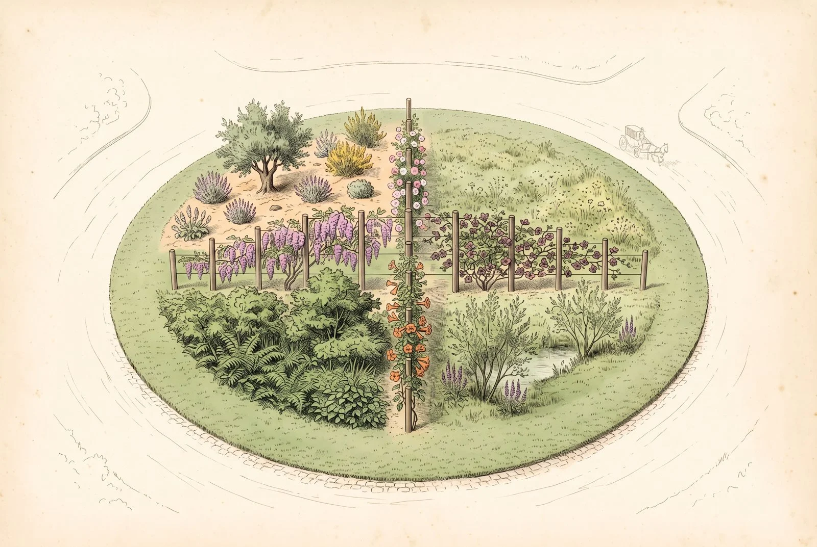
The cross roundabout: four quarters, one sowing, and each has made its choice.
The walls of climbers also act as the cues to care of chapter 5: their straight lines, regular posts and flowering tell everyone that this place is intended. The roundabout is, finally, the only place where toxic plants pose no problem at all, since nobody goes in: wisteria can cover one arm of the cross without risk to anyone. On the other arms, the large repeat-flowering climbing roses, akebia, cross vine, and why not a grapevine. Treated pine or black locust posts, stainless steel cables, a few bags of seed, the framework plants and their fixers: the investment is modest, and maintenance comes down to a short strip along the carriageway at the two annual passes on invasives and the annual input of ramial wood.
Two reservations, because the road has its rules. Safety first: a rigid post is an obstacle for a vehicle leaving the carriageway. The walls must therefore stay in the heart of the island, lower towards the edge, and stop well short of it, and their layout is approved with the road manager, according to the visibility and lateral obstacle rules he applies. Visibility next: the first metres along the carriageway stay low and mown so that motorists can see pedestrians and vehicles already on the roundabout; beyond that, as I wrote in “Heat in the city”, a shrub layer at eye height keeps the visual obstacle that slows traffic. These two points are not objections, they are design inputs, and they leave plenty of room for the cross in the centre.
The sunken roundabout, the one I proposed in “Heat in the city” with the roundabout turned upside down, a basin rather than a dome, is drawn differently. It has no cross. Water from the carriageway enters through the open edge, passes through a grille, a spill tank under the pavement and a small settling pond, as for any urban wetland, and runs down towards the centre; that is where, in the hollow, the wetland trees are grouped, alders and willows, on a waterlogged soil but with no open water at their feet. A few shallow ponds form at the sides, on the flatter parts of the slope, where water lingers after the storm. If one of them keeps at least fifty centimetres of water all year round, a water lily goes in. Around them, vegetation steps down outwards: shrubs on the drained slopes, then wet meadow, then the mown strip at the edge of the carriageway. The roundabout becomes a small stormwater management structure, and its shape alone is enough to say that it is intended. Hypothesis, to be tested on a first roundabout with a willing municipality.

The sunken roundabout: the storm runs down towards the alders and willows in the centre.
From the roundabout to the sunken park
The sunken roundabout is only the first step of a bigger idea, and I make it the centrepiece of this pact: the sunken park.
The idea fits in one image: making it normal for parks to sit lower than the road. Our parks are laid on top of the city, often higher than their pavements, and the storm that hits them races to the sewer like everywhere else. I propose turning them upside down, like the roundabout: a park dug in a gentle slope below the level of the surrounding streets, level with the street at its edges, down to two metres below it in the centre, and the pond lower still. The edge is open, and everything the neighbourhood can no longer drink runs down into the park.
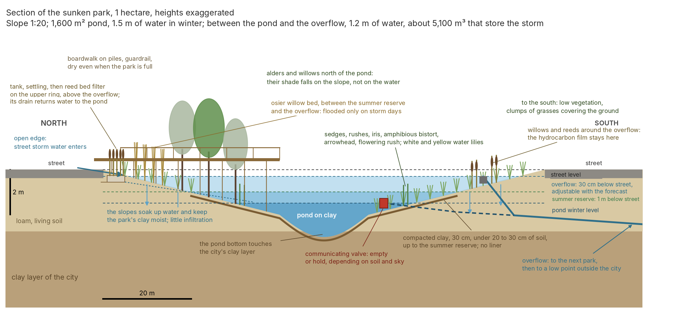
In the centre, a body of water on a clay layer. Not a concrete basin: a pond sitting on compacted clay, as I make all my ponds, then left to find its balance, early imbalances included, water that smells and then algae, then mosses and plants, then nothing but life. When dug, this pond often reaches the clay layer the city is built on, and it is that layer that makes it watertight without a liner. No liner, no geomembrane: public guidance points the same way, since the 2025 recommendations of the DREAL Pays de la Loire (the regional environment directorate) for creating ponds rule out plastic liners. Established for the recommendation. Clay is worked as it always has been: at least thirty centimetres compacted, laid in layers of fifteen to twenty centimetres, a clay rich enough that a sausage rolled between the fingers closes into a ring without cracking, and a trial pit that holds water before the works start. It lines the pond and rises to the level of the summer reserve, one metre below the street, and it is covered with twenty to thirty centimetres of soil, because clay that dries in the air cracks and does not become watertight again when the water returns. Above that level, no more imported clay: the slopes of loam and living soil soak up water and keep the clay under the park moist, instead of letting it crack under a scorched lawn; but they infiltrate only a tiny share of the storm, a millimetre a day on clay, and it is the valve, not the soil, that empties the park. The park’s job is storage and attenuation, not infiltration; what it can do for the clay under houses, I come to in the next chapter. Around it, the wet meadow, the common alders and the other wetland trees form a single organ with the pond. For one point must be stated precisely: a pond on clay holds water precisely because the clay is watertight, and it is not through the pond that water goes down under the city, it is through the slopes around it.
Around the pond, the layers of the pact. First the wetland trees, at the water’s edge, those that best tolerate having their feet flooded for a few days: common alders, white, grey, purple and osier willows, and white poplar, magnificent but suckering more than thirty metres from its foot, so reserved for large parks and kept in the heart of the hollow, away from networks and foundations. Alder fixes nitrogen and holds the banks; it is not planted alone, because alder Phytophthora is wreaking havoc in Europe. In the water and on the banks, the belt of emergent plants does the rest, and the fluctuation in water level dictates its choice: with a slope of one in twenty, the summer reserve floods a ten-metre-wide strip in June which gradually emerges again until September, so that each plant must tolerate fifty centimetres of water and then drying out. Reeds and bulrushes do not go into the pond: they have their place in the filters, which I come to in the next section. I let the bank colonise itself for two or three years, then I add native species under the Végétal local label, chosen for the fluctuating level: in the pond, which always keeps a metre and a half of water, water lilies wherever possible, white and yellow, Nymphaea alba and Nuphar lutea, with common club-rush; their leaves shade the water and keep it cool, and they are allowed to cover about half the surface, so that light still reaches the native water milfoils, spiked and whorled, which oxygenate the water by day; parrot’s feather and variable-leaf milfoil, banned in Europe, never. In shallow water, arrowhead and flowering rush with its pink umbels down to forty centimetres, water plantain and branched bur-reed at twenty centimetres or less; on the strip that floods and emerges, amphibious bistort, which floats when the water rises and straightens its stems when it recedes, greater pond sedge and lesser pond sedge, soft rush, yellow flag, purple loosestrife, yellow loosestrife; on the waterlogged edges, marsh marigold, water mint, water forget-me-not. Yellow flag is toxic, so it is kept away from the boardwalk. Established for the depths, taken from the sheets of a specialist aquatic nursery, and for the statuses. The same nurseries sell in their pond section dense waterweed, vallisnerias, aquarium milfoils from Oceania or America, galingales, pickerelweeds and tropical water hyacinths, giant reed, and even greater spearwort, protected in France: none of that in a park connected downstream. The nursery section is not a label, Végétal local is. Their tolerance of a metre twenty of water for two to four days of storm is a deduction, because English pond guides cap the surcharge at half a metre to spare the plants, and storms remain rare. Then the shrubs, elder, guelder rose, dogwood, spindle. At the top of the slope, at street level, I add an exception I stand by, arrow bamboo, Pseudosasa japonica. I use it regularly: it forms dense clumps, it is neither destructive nor invasive, and no French list flags it, neither the Île-de-France list nor the Brittany one. It gives what natives do not give in winter, an evergreen screen against the street, and canes that are harvested for the neighbourhood’s plant supports. Switzerland has nevertheless listed it among its invasives, and its fact sheet cites rhizome fragments carried off by floods. Hence my one rule: always above the overflow, never in the strip that the storm floods, so that no piece goes off to the next park.
Then all the rest of the park, managed as a space left free under the three rules: the legible frame at the top of the slope, at street level; the boardwalk on piles, which comes into its own here, since people go on walking on it dry on the day the park does its job and fills up; and a single clearing, which is not on the ground. For I state the principle of the sunken park clearly: it is a place where people can settle to watch the pond and its surroundings, a belvedere on the boardwalk, with its benches, its guardrail lined with fine-mesh netting between the rails, for small children and for animals, and its view of the water, the alders and the reeds; but for the rest, it is a wild area, reserved for nature and not for humans. No lawn, no picnics, no dogs, no foot on the slope: people come to look, as one looks at a reserve from its hide, and it is from this belvedere that the neighbourhood’s classes look at it too. It is not the neighbourhood’s playground, it is its second kind of park, and that settles at a stroke the question of drowning, of trampled banks and of birds nesting in the reeds: nobody goes down. A sunken park accepts being flooded a few days a year. That is not an accident, it is its function, and the entrance sign says so: today, this park is drinking for you.
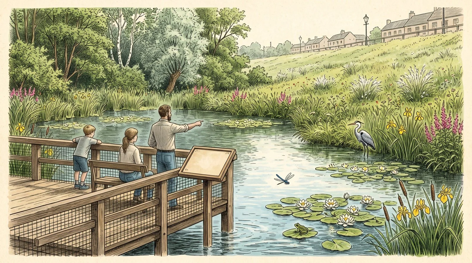
The belvedere: the only place where people settle. They watch the pond; nobody goes down.
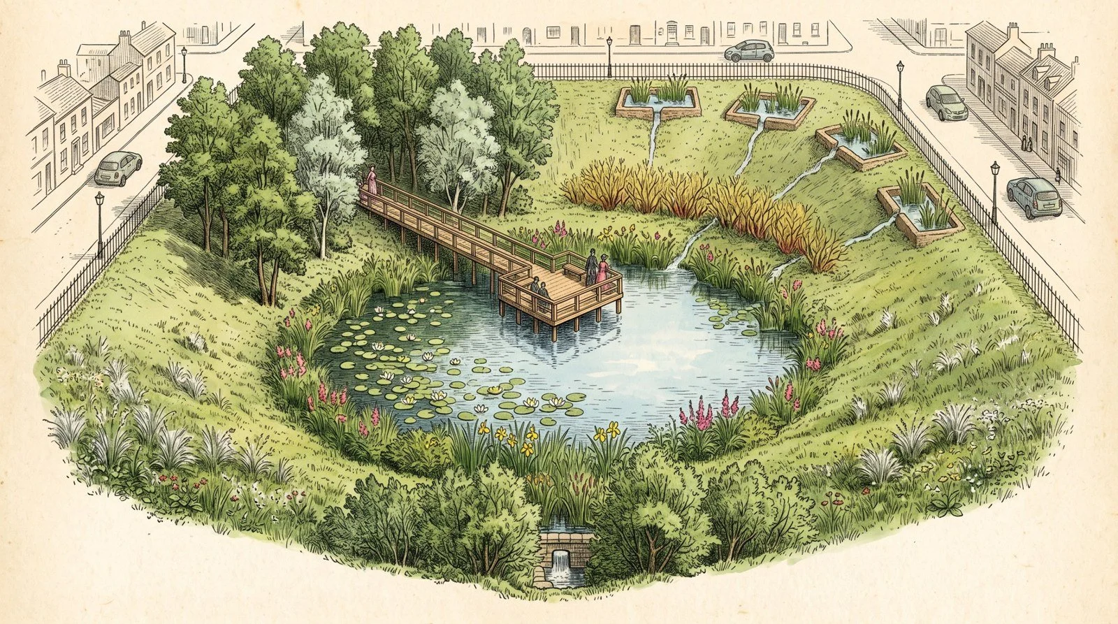
The sunken park: the neighbourhood slopes towards it, the pond on clay receives the storm.
Purifying street water
These areas must be a real system for treating road runoff, and not a showpiece that only looks like one. We are in the city, and the water running down from the street is not spring water: it carries tyre dust, zinc from roofs, hydrocarbons. What comes down is known: the Sétra method counts, per hectare of carriageway and per thousand vehicles a day, about forty kilos of suspended solids, 400 grams of zinc and 600 grams of hydrocarbons a year; for the eight to eleven hectares the park protects, that makes about ten tonnes of suspended solids and a few dozen kilos of zinc every year. Established. What works is also known: the vertical-flow reed bed filters that Cerema monitors at Moulins-lès-Metz, on gravel, and at Lingolsheim, on sand, whose water comes out at a few micrograms of zinc per litre, under five at Lingolsheim, and with no measurable suspended solids; and the filtering verges that Leesu monitored for eighteen months beside a departmental road, where zinc, lead and aromatic hydrocarbons are retained at around 90% for most rain events, less in winter when salt and fines pass through. Established for outlet concentrations; the percentage performance of the Cerema schemes is expected, not measured, for lack of inlet measurements, and I say so. The rule that makes the difference fits in one sentence: treat ordinary rain and store the storm. A filter receives the first ten to fifteen millimetres of each rain, that is, most of the year’s water and almost all of its load; the storm bypasses it by overflow and goes straight into the storage layer, because no filter treats a thirty-year rain and a flooded filter clogs. Hence a level rule I had first missed: the filters are not on the slope the storm floods, they are on the upper ring of the park, above the overflow, and they return their water to the pond through a drain. A filter flooded for two days in every storm would be dead in five years.
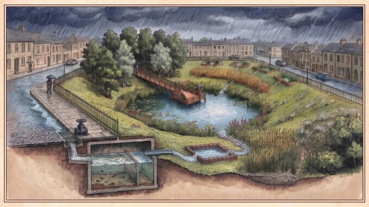
Hence the chain, in seven stages, from the gutter to the next park. A grille and a shut-off valve at each kerb inlet, closed by hand on the day a lorry spills its diesel. Then a spill tank, buried under the pavement, which catches sludge and litter before the water feeds the space: a concrete grit and oil separator, three to ten cubic metres depending on the area the inlet drains, with its siphon baffle that retains floating matter and its litter basket, emptied by vacuum truck once or twice a year, the sludge going to the non-inert waste stream. It takes the sand, cigarette ends, leaves and grease of the street, and it protects everything downstream from clogging. Next an open-air settling pond, twenty to thirty square metres, clay bottom kept wet, which deposits whatever fine matter remains, and is dredged every five to ten years; it is this pond, more than the plants, that decides the phosphorus level of the main pond, because road water carries three to five times too much of it to stay clear, and it is settling that removes it with the fines. Then the planted filter, on the upper ring: the Cerema schemes make up 0.9 to 3.7% of their active area, I retain one to two per cent, i.e. a thousand to two thousand square metres for eight to eleven hectares, shared between the inlets; sixty to a hundred centimetres of fine gravel on a drain, the bottom in compacted clay and not a liner, reeds and bulrushes at six per square metre. Common reed and bulrushes are found everywhere in nature, and they are the ones that do this work; they are readily classed as invasive plants, which is to misread them: they are vigorous natives, and that vigour is exactly what is asked of them here, in a filter they do not leave, and never in the pond. Their rhizomes eventually pierce the clay: they are contained by a cutting trench around the filter, opened every two years. Autumn mowing, removed, mainly takes out nitrogen; most of the metals stay in the tank and the settling pond. Then the osier willow bed, Salix viminalis, with almond willow and purple willow, managed as very short rotation coppice, cut back every two or three years in winter, the rods taken out of the park, to the neighbourhood’s basket-making or for energy, never into the chips. It too has its level: between the summer reserve and the overflow, where it is flooded only on storm days, and not below the reserve, where three months of water during the growing season would kill it. Willows are the best filters of heavy metals: in Brittany, the Wilwater programme reported, on willow coppices irrigated with effluent, a removal of cadmium and zinc by harvest greater than the inputs; in Quebec, phytofiltration willow beds capture more than 90% of nitrogen and phosphorus according to their designers. Reported, from the programmes’ own syntheses. For hydrocarbons, it is the soil life around the roots that breaks them down, and the willow feeds it; I hold this as a principle, without figures. And the willow drinks: its summer evapotranspiration is 1.1 to 1.8 times the reference value, enough to return part of the storm to the sky and cool the hollow in August. Then the pond, which receives filtered water in ordinary times and, several times a year, I say so, the raw storm, which rises into its upper layer and deposits its fines there: that is the price of storage, and the outlet siphon baffle and dredging pay it. Finally the outlet belt, and we know why it matters: hydrocarbons float, and when the park is emptied, the current carries the whole surface film towards the outlet. The filtering zone that matters most is therefore the one around the overflow and the valve, a belt of willows and reeds, where the film clings to the stems and the soil life breaks it down; the water intake itself is protected by a siphon baffle, that simple plunging wall of road retention basins which lets out only water drawn from below the surface. The film stays in the park, and the next park does not receive it. Living matter thus receives only water rid of its sand, sludge and litter; it does the fine work, on metals and hydrocarbons, that no tank does. And the rule applies to every urban wetland, not just the park: a sunken roundabout, a module pond, a swale that takes a street receive the same dirty water, and living matter touches it only after pre-treatment on its scale, grille, spill tank, settling, plus the planted filter once the drained area exceeds a hectare. A wetland that drinks the street without pre-treatment is a mud basin within ten years. What nothing retains, I write down too: de-icing salt passes through everything and concentrates in the reserve in summer, and a share of the dissolved metals passes with the organic carbon. The answer lies upstream, less salt on the streets that slope towards the park, and annual monitoring of chlorides in the pond. Each park is measured, and it is for the specification to require it.
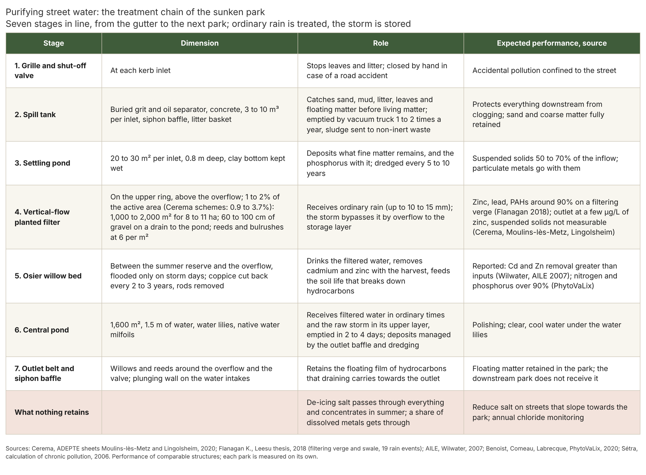
Purifying street water: the treatment chain of the sunken park.
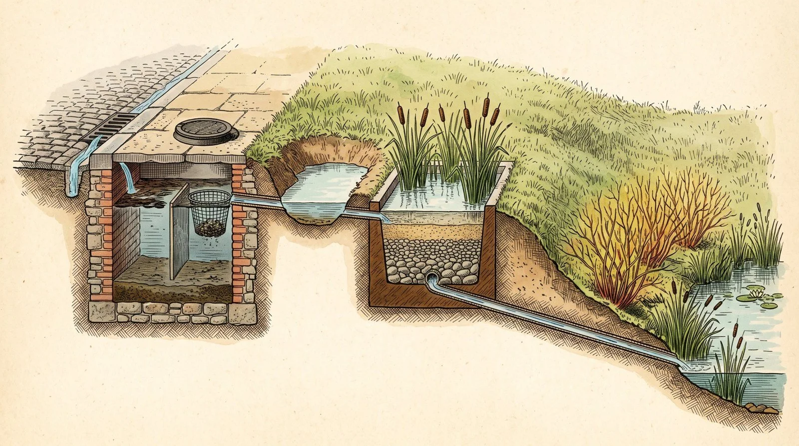
The water inlet in cutaway: grille, tank, settling, planted filter, then the pond.
What a sunken park drinks
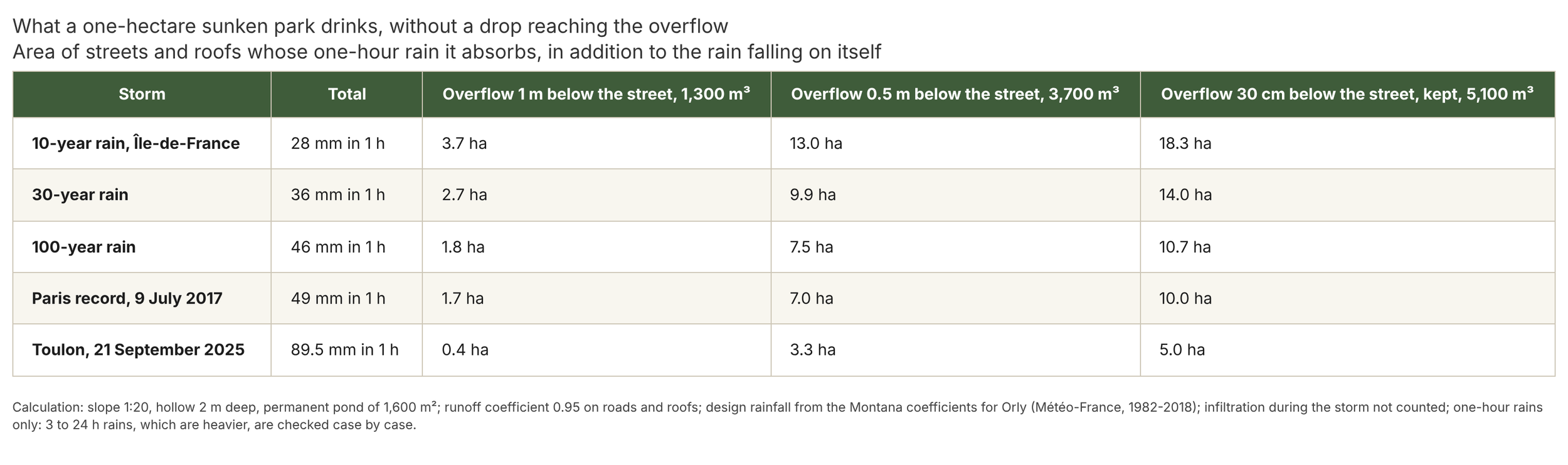
I wanted to put figures on the idea before anyone asked. Take a typical one-hectare park, a hundred metres by a hundred, dug in a gentle slope, one in twenty, down to two metres below the street, with a permanent pond of 1,600 square metres whose normal level is a metre and a half below the road. The overflow is not flush with the street: it is set thirty centimetres below it, so that the park never overflows onto the pavement and keeps a safety margin. Between the normal pond level and this overflow, the layer of water that rises during the storm is 1.20 metres deep and stores about 5,100 cubic metres. For comparison, a more cautious overflow, fifty centimetres below the street, would store only 3,700, and at one metre, 1,300: every decimetre gained towards the street is paid for in cubic metres, because it is the top of the basin, the widest part, that stores the most. In the centre, the pond is dug deeper, to about three metres below the street, to keep a metre and a half of water at its winter level: enough to stop the water warming too much, as pond guides require, which range from one to two metres. Its banks, for their part, cannot be at one in twenty: to drop a further metre fifty over twenty metres’ width, they are at one in three or one in five, under the permanent water, where nobody goes; the gentle slope applies to the park, not to the bottom of the pond, and the pond adds two thousand cubic metres to the spoil. My own calculation, on a simple geometry, to be redone site by site.
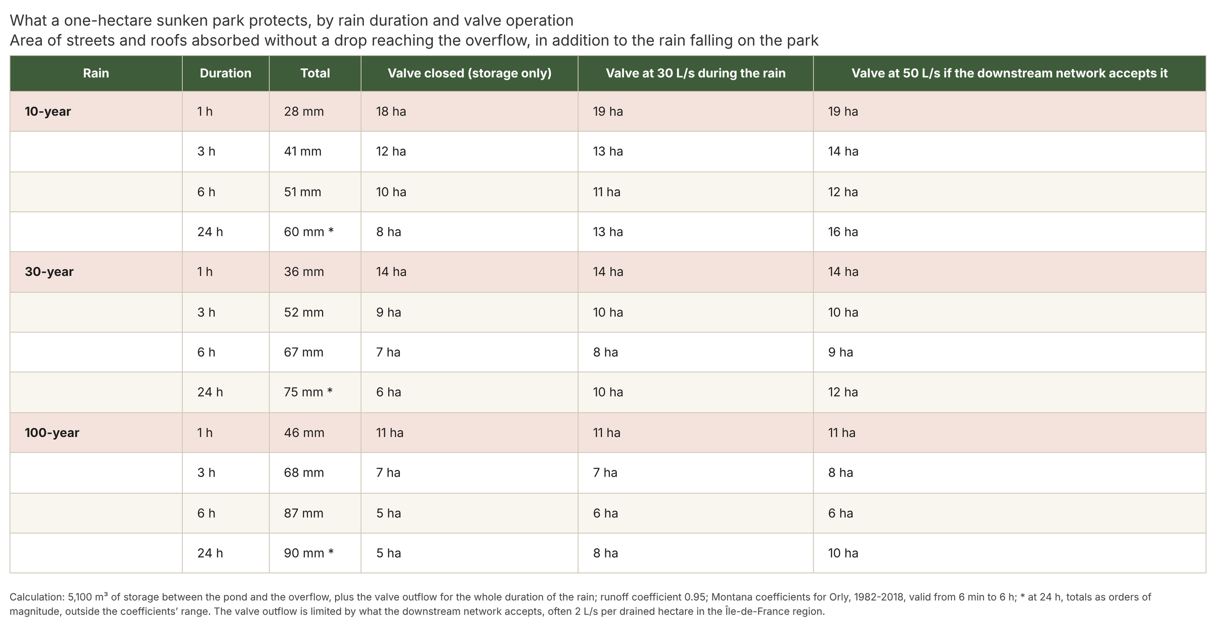
What this represents is counted in storms. For the design rainfall of the Île-de-France region, calculated from the Montana coefficients of the Orly station published by Météo-France, the ten-year rain brings 28 millimetres in one hour, the thirty-year 36, the hundred-year 46. The Paris record, on 9 July 2017, was 49 millimetres in one hour, beyond the hundred-year rain. And Toulon received 89.5 millimetres in one hour on 21 September 2025. With a runoff coefficient of 0.95 on roads and roofs, the coefficient used in the Hauts-de-Seine sewerage regulations, the typical park drinks, without a drop reaching the overflow, the one-hour ten-year rain falling on 18 hectares of streets and roofs, the hundred-year rain on nearly 11 hectares, and even the 2017 Paris record on 10 hectares; in Toulon, it would still have drunk the storm from 5 hectares. Calculated, and cautious on one point, since I do not count the water the slopes infiltrate; but not on another, since a storm can last more than an hour. The same ten-year rain spread over three hours brings about 40 millimetres, and the hundred-year rain nearly 70. Actual sizing is therefore done on rains of three to twenty-four hours, with the valve working during the storm, and site by site. So I redid the calculation with the two terms that matter: storage, and the valve’s discharge capacity during the rain, as an hourly flow, limited by what the downstream network accepts. For a one-hour rain, the valve changes nothing, the park stores. Over six hours, the ten-year rain makes 51 millimetres and the park protects ten hectares with the valve closed, eleven with the valve at 30 litres per second; the thirty-year rain, 67 millimetres, seven to nine hectares; the hundred-year rain, 87 millimetres, five to six. Over twenty-four hours, it is the valve that makes the difference: eight hectares without it, thirteen to sixteen with it, for the ten-year rain. The figure a city should remember is therefore not eighteen, it is eight to eleven hectares per park for six-hour rains, and ten parks in a chain, eighty to a hundred and ten, with a valve that works. My own calculation, and it depends on many parameters, to be redone on each site with the network operator, who alone knows his hourly discharge rate. And one more thing must be said: yesterday’s ten-year rain is becoming the rain of every two years, or even every year. That does not change the park, it changes how often it fills; and a park that fills twice a year must be empty for the next rain. The ratio between storage and emptying then becomes the real sizing criterion, more than the volume itself: it is the valve, its regulation and the downstream network that decide whether the park is ready on the day the storm returns.
The grid multiplies these figures. Ten one-hectare sunken parks together store 51,000 cubic metres, enough to protect eighty to a hundred and ten hectares of streets and roofs in six-hour rains, that is, a whole neighbourhood; and when one is full, it passes its excess to the next. There are two systems for this, and both must be discussed. The first is the gravity cascade, in a sloping city: a free-surface pipe, with its own gradient, that discharges above the water of the downstream park; each link requires two to four metres of drop from street to street, and it is the relief that draws the grid, towards the river or the low point. It is the simplest system, with no particular maintenance, and it is the one for hillside towns. The second is for the plain, where I will rightly be told that those metres do not exist: it is the inverted siphon, a pipe laid below the water level on both sides, always full, working under pressure. What makes it flow is not the slope of the ground, it is the difference in level between the two water surfaces, and each park creates that difference itself: between its overflow at thirty centimetres and its pond at one metre fifty, it has one metre twenty of head, however flat the city. That head exists only if the downstream park is kept lower than the upstream one: as soon as the two water surfaces line up, the flow drops to nothing. So the levels must be held in steps, upstream slightly higher than downstream, which the valve and the adjustable sill do, and the water pushes from park to park, as slowly as one decides, down to the last, whose valve leads to the outfall. For four hundred metres of pipe and a one-metre difference in level, a three-hundred-millimetre diameter passes about sixty litres per second, a four-hundred, a hundred and twenty: far more than the valve lets out, and the valve is what throttles. My own calculation, as an order of magnitude. In a large storm, the chain balances and fills together, and it is the sum of the volumes that counts, slope or no slope; the drop only decides the final outlet, because the low point outside the city must be below the pond of the last park, otherwise a pump is needed, and I write that down. And the final outlet is sized for the whole chain, not for one park: ten parks emptying through a 30-litre-per-second valve would take twenty days, which ruins the four-day rule and leaves the chain full for the next storm. The Île-de-France regulations allow 2 litres per second per drained hectare, i.e. 200 to 280 litres per second for a hundred to a hundred and forty hectares: that is the flow to which the last park’s valve and the last siphons are sized, and the chain is emptied in four days.
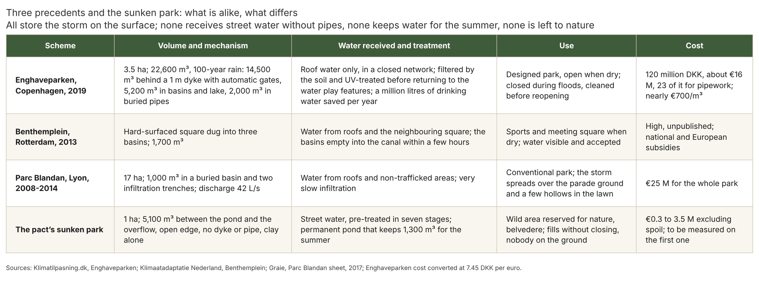
The siphon has its constraints, and the first is cleaning. A pipe that is always full, with no current between rains, silts up: the fines that got past the filtering belt settle in it, and a silted pipe is a park that no longer empties. This is not ignored, it is planned for: a cleaning chamber at each end, accessible to the vacuum truck, with a low purge point; no flushing, because a metre twenty of head never gives the metre per second that would put sediment back into suspension over four hundred metres, and I would rather write that than promise it; so mechanical cleaning written into the maintenance plan, every year at first, then at the rate the chambers show, at the same time as the settling ponds; and, upstream of the intake, the belt of willows and reeds and the siphon baffle, which ensure the siphon receives no floating or coarse matter. The second constraint is air: a pressurised pipe that partly empties loses its prime, and it needs a vent at its high point. The third is crossing streets, where the pipe crosses the utility networks; that is a cost per crossing, not an impossibility, and it is the road manager who prices it. Copenhagen built the cascade before us. After the storm of 2 July 2011, more than a hundred millimetres in about two hours and some 90,000 insurance claims, the city adopted a plan of three hundred projects, including floodable parks: Enghaveparken, three and a half hectares opened in 2019, stores 22,600 cubic metres, a hundred-year rain: 14,500 behind a one-metre dyke whose gates close automatically, 5,200 in basins and a lake, 2,000 in buried pipes. It receives only roof water, through a closed network, filtered by the soil and treated with ultraviolet light before returning to the water play features; it is closed to the public during floods and cleaned before reopening; it cost a little under 120 million kroner, about 16 million euros, of which 23 million kroner for pipework, i.e. nearly 700 euros per cubic metre. The economic analysis published by the European Environment Agency puts the whole plan, surface and tunnels, at 11 to 12 billion kroner, against 20 billion for the all-sewer option, after more than 6 billion of damage in 2011. Rotterdam dug its Benthemplein water square, three hard-surfaced basins of 1,700 cubic metres in all, a sports ground when dry, which empty into the canal within a few hours. In France, the Parc de Billancourt in Boulogne has its sunken gardens, and the Parc Blandan in Lyon, seventeen hectares, stores 1,000 cubic metres in a buried basin and two very slow infiltration trenches, with a discharge rate of 42 litres per second, and holds the storm on the surface on its parade ground and in a few hollows of its lawns. Established for these schemes. The comparison shows what the sunken park shares with them and what is its own. In common: all store the storm on the surface, instead of in a tunnel, and Copenhagen has proved it is cheaper. Its own, four things none of the three does: it receives street water through its open edge, without pipes, and treats it in seven stages, where Copenhagen dares to take only roof water; it keeps a permanent pond and 1,300 cubic metres for the summer, where the others empty; it holds by clay alone, without a dyke, without an automatic gate in a wall, without buried pipes; and it is not a designed park that is flooded and closed, it is an area left to nature, where nobody is on the ground, which fills without closing. It is also the only one of the four that does not exist yet, and that is why the first one must be measured.
And cost follows. The French syntheses taken up by Brussels Environment give 800 to 1,000 euros per cubic metre for a buried storm tank in the city, 60 to 220 euros for a rustic open-air retention basin, and about 700 euros for an equipped urban park such as Enghaveparken. The 5,100 cubic metres of the typical park would therefore cost 4 to 5 million euros under a carriageway, and from 0.3 million for a simple basin to 3.5 million for a fully equipped park; the sunken park, which is a park without all a park’s equipment, falls between the two, land and maintenance not included, and earthworks separate: the basin represents about 8,300 cubic metres of spoil, the pond two thousand more, which cannot all be reused on site without closing the open edge, and which cost, in the Île-de-France region, from 0.5 million if inert to 2.5 million if they carry the lead and hydrocarbons of an old city. That is why the sunken park is justified first on a site that is already low, a former quarry, a wasteland below street level, an existing park lower than its streets. And there is one soil that is never treated as spoil: the topsoil, the first thirty centimetres, which contains what nothing can buy, the site’s bacteria and mycorrhizae. Before the first spadeful, it is stripped separately, stored in low windrows, never more than a metre fifty, never driven over by a machine, in the shade of a sown cover, and upstream of the works a storage and composting area is set up, fed with the municipality’s chipped prunings, which will then be used to seed the whole park with bacteria and mycorrhizae. A living soil is not recreated in three years; it is kept during the works, and it is the setting up of the site, depending on what is found upstream, that decides what the park will be ten years later. Order of magnitude established; it is redone on each project.
There remains emptying, which complements the overflow without replacing it. After the storm, there is a choice, and that is the whole point: at the normal pond level, a communicating valve connects each park to the same pipe as its overflow, towards the next park. As long as the sky is calm, it can be kept closed for a day or two, while the fines settle and the slopes soak; but on clay, the soil does not empty the park, eight cubic metres a day over seven thousand square metres, and it is the valve that does it. As soon as a new storm is forecast, or at the latest on the fourth day, it is opened, and the park empties downstream so as to be ready to drink again. At twenty litres per second, the 5,100 cubic metres go in three days; at thirty, in two, with a regulated valve, because a simple open valve discharges less as the park empties. And the mosquito rule sets the ceiling: the storm layer is never left standing for more than four days. These valves, opened or closed from park to park depending on whether the downstream park can receive, turn the grid into a single structure that is operated, and the overflow remains the safety valve for the exceptional storm.
These valves allow something better still: keeping spring water for the summer. That is why the sunken park must offer a large floodable area, and not just a margin: at the overflow, water covers nearly 7,700 square metres, three quarters of the park. The calendar decides, and precision is needed, because both seasons are risky for different reasons. Paris climate normals give May and December as the wettest months, and network overflows come from the convective storms of June to September, the most violent per hour; but what was seen in the autumns of 2023 and 2024 were the long rains of October to January, on soils that low winter evaporation no longer dries out, and which overflow differently, through saturation. From October to January, then, the park is not storing water, it is managing risk: valve open, overflow sill at its lowest, pond at its winter level, the whole basin free, and it is emptied after every rain to be ready for the next. From February to May, the job changes and storage management begins: the valve is gradually closed, and the late winter and spring rains are allowed to raise the pond by half a metre, up to one metre below the street, about 1,300 cubic metres put aside for the summer; thirteen millimetres of runoff over ten hectares is enough, and May provides it. From June to September, it is storm season: the reserve is full, and the upper layer stays free, with the valve and sill ready to work. At the end of September, the level is brought down before the autumn rains. Two modes, two settings, a switchover date decided each year from seasonal forecasts. The upper layer, from one metre to thirty centimetres below the street, always stays free, because summer storms are the most violent; and as it is the widest part of the basin, it still stores nearly 3,900 cubic metres, enough to drink the ten-year storm from 13 hectares or the hundred-year storm from nearly 8. Calculated.
This reserve serves the city all summer. It keeps the wet meadow and the trees supplied with water during heatwaves, when the rest of the city scorches. The tank that waters the neighbourhood’s street trees, as I proposed in “Heat in the city”, is filled in spring by the overflow, when water is in excess, and not by drawing on the reserve in summer, which must serve only the pond and its trees: the reserve is not pumped. It makes a reserve against fire. And above all, it evaporates, and that is a service, not a loss: at four millimetres of evaporation a day, a summer order of magnitude in the Île-de-France region, plus the small millimetre that a well-made clay lets leak, the reserve drops by about five millimetres a day and lasts a little over three months, just the length of a summer. Evaporating ten to fourteen tonnes of water a day takes 300 to 400 kilowatts on average, my own calculation as an order of magnitude, but this energy is taken from the sunlight the water absorbs, not from the air, and a meadow or a wood supplied with water evaporates as much without storing the heat for the night. So I stand by it: the sunken park provides three services, it stores water for the summer, it regulates heavy rain, and it keeps its clay moist and gives the neighbourhood the means to keep its own against shrink-swell. Coolness comes as a bonus, from its trees that transpire in August when those in the streets close their stomata; the pond, for its part, serves the water. And that is where the vegetation around and in the pond takes on its full value, because that is when the whole system starts working together. The water of a pond holds in one of two states, and each sustains itself: clear water, where plants dominate, and turbid water, where algae dominate; water lilies shade the surface and slow warming, water milfoils and other submerged plants oxygenate the water through photosynthesis, shelter the zooplankton that graze the algae, and fix nutrients in their tissues rather than in the open water. The more vegetation there is, the more oxygenated the water and the more it purifies itself; this can be seen on clear-water ponds, and it is what shallow-lake ecologists have established over thirty years under the name of alternative stable states. Established. It is also the real answer to the blue-green algae of storm basins: a pond that has its plants keeps its water clear, a pond that has none tips over in the first hot summer. In a very dry summer, drawing on the reserve stops before it reaches winter level: the bottom of the pond must never see the air. A design precaution follows: the basin must descend at an even slope, without hollows or isolated puddles, so that the water receding in August leaves behind no standing water separated from the pond, where mosquitoes would find their place.
It remains to be honest about what this requires. A soil survey first, because digging an urban wasteland without a diagnosis can stir up buried pollution; the good news is that most road runoff pollutants, metals and hydrocarbons, stay fixed in the first fifty centimetres of soil, and that a grassed strip at the top of the slope stops them before the pond. Sewerage sizing next, approved with the network operator, because the cascade of overflows is a hydraulic structure, not a drawing. Safety next, because a public body of water is designed for the child who approaches it. The park’s one-in-twenty slope is much gentler than what pond guides require, which tolerate one in three with a safety bench, and the steep banks of the pond are under permanent water, behind the belt of plants; and the thirty-centimetre margin between the overflow and the street is the minimum in the English reference guide for stormwater structures, CIRIA C753; English operators rather ask for forty to sixty centimetres and cap water depth at one metre for the hundred-year rain. Established. To decide between thirty and sixty, weather information is needed in advance, and that is why I do not decide once and for all: I set the maximum filling at thirty centimetres below the road, and I propose a grid of adjustable overflows, a stoplog sill that is raised or lowered, which leaves the operator free to choose according to weather data or circumstances. Thirty centimetres in calm weather, fifty or sixty when an orange alert is announced or the downstream park is already full: the margin is no longer a figure set in stone, it is a decision taken the day before, with the same remote management as the valve. A full park is not a puddle: at the overflow, there is nearly two metres of water over the bottom of the park and nearly three in the pond. But nobody goes down to the ground: the public stays on the boardwalk, which has a guardrail along its whole length, and a dense belt of sedges and rushes two to three metres wide still separates the slope from the open water; during the two to four days when the park is drinking a storm, the sign says so, and the belvedere becomes the best place in the city to watch the storm at work. Finally, the red swamp crayfish and the muskrat dig into banks: the gentle slope and the soil covering the clay limit their damage, without removing the need for monitoring. And the distance from houses, discussed above. Established for landscaped retention basins, of which our planted storm basins are cousins; hypothesis for the whole, the public park left free in a hollow, its effect on the clay and its cascade, to be tested with a willing municipality, a hydrogeologist and a winter of storms.
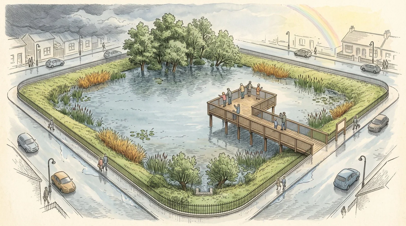
The day after the storm: the park is full, the streets stayed dry.
2. What the park brings, and the clay
I take what the park brings item by item, starting with what is most expected of it and least certain, coolness. The pond feeds coolness: it is evaporated water that cools, as I wrote in “Heat in the city”. The meta-analysis by Völker and colleagues in 2013, covering twenty-seven studies, finds urban blue spaces 2.5 degrees cooler on average during the hot months, mostly in surface temperature, since air at head height near a small body of water drops by only a few tenths of a degree; and the review by Bowler and colleagues gives parks almost one degree of coolness on average by day, 0.94 exactly, noticeable up to a kilometre for large parks, a hundred or two hundred metres for a hectare, roughly its own width. Established. But these figures measure a body of water alone or an average park, and that is not what I propose. The vegetation as a whole must be taken into account, the trees, the wet meadow and its grasses, the bamboo at the top of the slope, the water vegetation, reeds, bulrushes, water lilies, submerged plants, and nobody has measured what the sum is worth. It is hard to calculate, and I do not calculate it. What ecology has established, on the other hand, across hundreds of experiments, is that the higher the biodiversity of a habitat, the more it produces, the more it retains nutrients, the better it resists shocks, and that the services it provides rise with it; the synthesis by Cardinale and colleagues, in Nature in 2012, settled it. So I take the direction as given, and the figure as hypothesis: the higher the park’s biodiversity, the higher the services it provides to the city, heat along the way, fewer mosquitoes, capture of pollutants and ozone, and the first park will measure it. The effect of a body of water remains local, a few dozen metres, and in the evening the water returns part of the heat it took in by day; a shallow pond, at twenty degrees in July, gives this heat back from the evening, and the air in the hollow, laden with moisture, can be heavier than in the street between midnight and dawn. That is a price to pay for the water, not a benefit, and I write it down. Hypothesis for the night-time behaviour of the hollow, to be measured on the first park. What matters then is how the vegetation is organised. The trees always go to the north of the pond, so as not to shade it too much: a pond needs its sun, which drives the water lilies and submerged plants that keep the water clear, and the shadow of the alders, to the north, falls on the slope and not on the water. Nothing prevents low vegetation all around and up the slope, however, in particular clumps of grasses, which protect the soil, keep it covered and cool, and slow the water running down. As for mosquitoes, I must correct the received idea in both directions. An established permanent pond, populated by dragonfly larvae, diving beetles and backswimmers, is not a major breeding ground: on a new urban wetland in the United Kingdom, Medlock and Vaux counted Culex larvae thirty-three times denser in temporary water than in permanent water. Established. But a new pond, without predators, is one for a year or two, and not all studies find that more predators means fewer mosquitoes. The tiger mosquito, for its part, lays in saucers and gutters, not in ponds. Hence a rule of conduct rather than a promise: permanent water that never dries out, and a storm layer that empties in less than four days, before a larva has time to become a mosquito.
The city’s clay
I believe the pond on clay also protects the city’s clay and feeds it, and that sunken parks in a grid would cushion from below the shrink-swell that cracks houses in every drought. I must say frankly that this is a hypothesis, and that official doctrine currently points the other way: the French Ministry of Ecology and the risk prevention plans call for keeping rainwater and thirsty trees away from foundations, infiltration structures at a distance at least equal to their depth, trees at one, or even one and a half, times their adult height, and the DRIEAT (the Île-de-France environment and planning directorate) asks for any infiltration near foundations to be avoided. But the same Hauts-de-Seine regulations, in 2022, state that on swelling clay, not infiltrating can be the real risk: that is exactly my hypothesis, and it is a State service that writes it. And one thing must be seen first in shrink-swell: it is not water that cracks houses, it is alternation. Clay swells when it gets wet and shrinks when it dries, and it is the back and forth, year after year, that splits walls; clay held at constant moisture does not move. That is why I speak of maintenance, and nothing else: a permanent area of water touching the clay buffers the clay zone, gives it a stable state, and that is the purpose for which the park is designed. We are not looking at adding water from time to time, a storm infiltrated here, three dry months there, which would be exactly the cycle that breaks things, and would be catastrophic at the foot of a house. That is in fact what the doctrine keeping infiltration away from foundations is aimed at: intermittent water, not constant water. The pond on clay, which never sees the air, is the opposite of a soakaway. But I must also say what does not fit, before a geotechnical engineer says it for me: range. Clay is not sand, moisture spreads through it by diffusion, slowly, and over a summer the pond and the soaked slopes keep moist the clay under the park’s footprint and a fringe of a few metres, one to three, no more. At twenty or thirty metres, where the houses are under my own rule, the park has no effect on their foundations, good or bad. My own deduction, from the diffusivities of clays. The park therefore holds its own soil, and that is already something, a hectare of clay that no longer cracks; but it does not hold the neighbourhood’s.
That is where we come back to my basic idea: drip emitters along houses, linked to probes. Cerema has experimented with it, and I cite the study because it is the proof of the maintenance doctrine at the scale that matters, that of the foundation. The MACH project, Maison Confortée par Humidification (a house stabilised by humidification), ran from 2016 to 2020 in Mer, in the Loir-et-Cher, on a 1968 house that cracked in the summer of 2015, on brown decalcification clay. Rainwater, stored in a 2,000 then 2,300 litre tank, is injected by gravity at the foot of the gable wall whenever the tensiometers, at one metre depth, exceed a suction threshold; the cracks are monitored by gauges, all transmitted remotely. It took 2,660 litres in 2017 and 4,010 litres in 2018, a drought year in which the system several times reached its limit, and the injections triggered at the suction peaks brought suction down and stabilised the cracks. Demonstrated on one house, by a public body, without peer-reviewed publication; an extension to about thirty houses with an insurer was launched in 2023 and its results have not been published. So I write it as a demonstrated case being replicated, not as an established rule. Three to four cubic metres per house per year: the park’s summer reserve, 1,300 cubic metres, is enough to supply three hundred. That is the park’s real service for the neighbourhood’s shrink-swell: not holding the houses’ clay at a distance, which it cannot do, but being the reservoir that supplies, house by house, for willing owners, a buried drip network along the foundations, controlled by suction probes, which gives each house’s clay what the pond gives its own: a constant state. It is measured prevention, at a few thousand euros per house, against an average claim of more than 20,000. I write it as hypothesis for the connection to the park, and as a demonstrated case for the mechanism, since Cerema made it work once. What MACH did not settle, and what Cerema’s guides object, must also be said: they call for keeping water away from foundations, for three reasons that apply to the emitters. Wetting only one façade, which MACH does at the gable, creates differential swelling, as dangerous as shrinkage: the network must go all the way round the house. Rewetting clay that has been shrunk for years lifts it as much as a drought cracks it: start early, and slowly. And water at the foot of a wall seeks out the basement and crawl space through existing cracks: the probes and the automatic cut-off are there for that, and emitters are not placed against a leaking wall. And this is the moment to say that the house does not need to wait for the park. In the countryside, where the house is not connected to the mains sewer, we are talking about blackwater, toilet water included, and on-site sanitation does the work: a phytopurification area, a reed bed filter, receives all the house’s water, purifies it, then returns it to the soil through a dispersal field. It is enough to insert a tank, placed between the filter and the dispersal field, and it is this tank, not the drinking water supply, that feeds the controlled emitter network around the house. The chain is simple and closed: the water is treated by phytopurification, purified, then filtered a second time at the tank outlet, and reinjected underground, never on the surface, to avoid any risk of contaminants; and it is controlled by probes set in the clay around the house, which trigger injection when the clay starts to pull and stop it when it has returned to its state. On-site sanitation regulations themselves provide for this outlet: the French order of 7 September 2009, amended in 2012, allows in its article 11 the reuse of treated water for the subsurface irrigation of plants, within the plot, except for plants intended for human consumption, provided it neither ponds nor runs off on the surface. Buried emitters along foundations, under covered soil, meet these conditions to the letter. The volumes match: a house discharges a hundred and fifty litres per person per day, thirty times what MACH needed to inject over a summer, and the surplus goes to the dispersal field as it does today; but the clay under the foundations no longer knows summer. This is the system I install for private clients, and it is the same principle as the park, at garden scale: a living filter, a reserve, probes, and a constant state for the clay. I hold it as established in its mechanism and regulatory framework, and as hypothesis in its results on cracks, which no study has yet measured at this scale; MACH did it with roof water alone, and treated water only changes the volume available, which becomes unlimited.
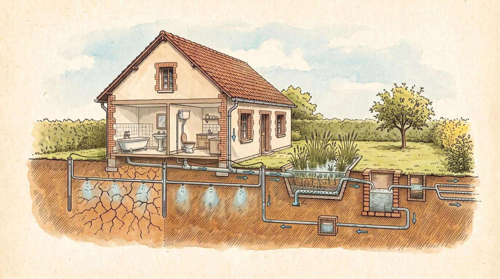
The house on clay: filtered water, tank, and probe-controlled emitters around the foundations.
Active moisture stabilisation of clays is precisely what the national Initiative Sécheresse programme is evaluating today, from 2023 to 2028. The sunken park is a lead for it, not a given. Hence two rules that are not open to debate: the sunken park is kept at a distance from houses, and its large wetland trees stay twenty or thirty metres from any building. The hydrogeologist decides the rest, case by case, because depending on the soil the same hollow can dry out its surroundings instead of feeding them.
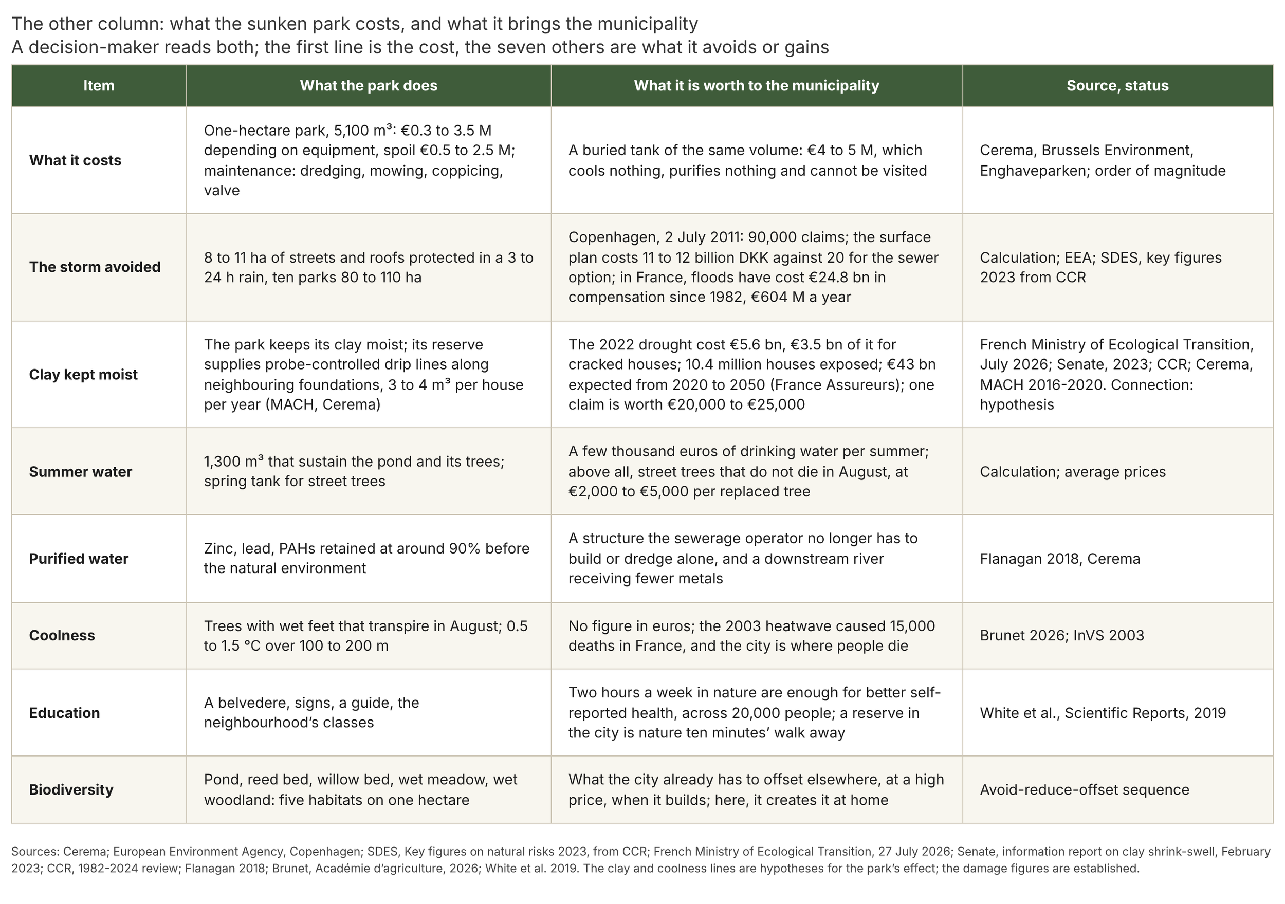
The other column
Cost is obviously what a decision-maker will look at first, and I have just given it without playing it down. But a decision-maker also looks at the other column, what the park saves and what it brings to the municipality, and it is on these points that detail is needed, so that the full range of benefits the city can draw from it is understood. I take them one by one.
The storm first. A one-hectare park protects eight to eleven hectares of streets and roofs in long rains, ten parks eighty to a hundred and ten. What this protection is worth, Copenhagen put a figure on after 2 July 2011: 90,000 insurance claims, then a surface plan at 13 billion kroner against 20 for the all-sewer option, a difference of seven billion for a single city. In France, floods have cost 24.8 billion euros in compensation since 1982, 604 million a year on average, and these are figures from the Caisse centrale de réassurance (CCR, the state reinsurer). Established. And for the same stored volume, the buried tank costs 4 to 5 million, cools nothing, purifies nothing and cannot be visited.
The clay next. The park keeps its own soil moist, and its reserve can supply the upkeep of the neighbourhood’s foundations, house by house, on the MACH model; this is where the other column becomes heavy: the 2022 drought cost France 5.6 billion euros, 3.5 billion of it for houses cracked by shrink-swell, figures given by the Minister for Ecological Transition in July 2026; 10.4 million detached houses are exposed according to the BRGM (the French geological survey), more than half the housing stock, and France Assureurs expects 43 billion in damage from 2020 to 2050, three times the previous thirty years; a claim is worth 20,000 to 25,000 euros, 21,000 on average over 1990-2015 according to the CCR. Established for the damage. For the park’s effect, I stay with hypothesis, and I draw the consequence: the first park would only need, through the emitters it supplies, to avoid a few dozen claims in its neighbourhood over twenty years to pay for itself, and that is exactly what the national Initiative Sécheresse programme is due to measure. A city that builds a sunken park next to a neighbourhood of houses on clay is not making a garden, it is doing prevention.
Summer water: 1,300 cubic metres that sustain the pond and its trees, and a tank filled in spring by the overflow for street trees, a few thousand euros of drinking water per summer, which is little; but above all, street trees that do not die in August, at two to five thousand euros per tree to replace, and a city that does not close its parks because of scorched lawns. Purified water: a structure the sewerage operator no longer has to build or maintain alone, and a downstream river receiving fewer metals and hydrocarbons, which the Water Framework Directive requires of it anyway. Coolness: no figure in euros, but the 2003 heatwave caused 15,000 deaths in France, and it is in the city that people die. Biodiversity: five habitats on one hectare, pond, reed bed, willow bed, wet meadow, wet woodland, which is what the municipality already has to offset at a high price, elsewhere, every time it builds; here, it creates it at home.
And education, which I put last because it may be the first benefit. Bringing nature into the city, observing it and explaining it, is the most lasting thing a municipality can offer its residents, and it costs only signs: a belvedere on the boardwalk, signs that say what the park is doing that day, the water rising, the alders drinking, the dragonflies hunting mosquitoes, a guide for the neighbourhood’s classes, an outing ten minutes’ walk away for every school. Across nearly 20,000 people in England, White and colleagues showed in 2019 that two hours a week spent in nature are enough for better self-reported health and wellbeing, whatever the age, income and neighbourhood. Established. A nature reserve in the heart of the neighbourhood puts those two hours within everyone’s reach, without a car, and it is a generation of children who will know what a pond is.
3. The clauses of the sunken park
I give them here in summary, like those of the second episode; the full sheet, reusable on assignments, accompanies this text.
On sunken parks: gently sloping profile below street level, open edge with water inlets fitted with grilles and a grassed strip at the top of the slope; overflow with adjustable sill, set by default 30 centimetres below street level, which can be lowered to 60 centimetres depending on weather forecasts and the state of the downstream park, operated together with the valve by the same remote management; communicating drain valve regulated at the normal pond level, connected to the downstream park, operated according to soil infiltration conditions and forecasts, sized to empty the storm layer in less than four days; seasonal management in two modes: from October to January, risk mode, valve open, overflow sill at its lowest, pond at winter level, emptying after each rain; from February to May, storage mode, gradual closing of the valve, summer reserve filled by late winter and spring rains up to 1 metre below the street; from June to September, reserve held and upper layer kept free for storms, valve and sill on standby; summer reserve never pumped, irrigation tank filled by the spring overflow; return to risk mode at the end of September; switchover dates set each year from seasonal forecasts; basin with an even slope, with no isolated depression; park at a distance from buildings, large wetland trees at least twenty or thirty metres from any construction; storm layer kept away from all buildings; summer reserve connectable, for willing owners, to buried drip networks along foundations, controlled by suction probes at 1 metre depth with a trigger threshold, on the model of Cerema’s MACH experiment, 3 to 4 cubic metres per house per year; at the scale of a detached house with on-site sanitation, a reed bed filter treating all domestic wastewater, a tank between the filter and the dispersal area, secondary filtration at the tank outlet, reinjection exclusively underground through buried emitters along the foundations, with no surface discharge, controlled by suction probes set in the clay around the house, network running all the way round the foundations, gradual commissioning, automatic cut-off when moisture exceeds the threshold, excluding walls cracked below ground, under the subsurface irrigation of plants not intended for human consumption provided for in article 11 of the amended French order of 7 September 2009, with no ponding or surface runoff, excluding plants intended for human consumption; no liner or geomembrane: central pond dug to about 3 metres below the street, 1.5 metres of water at winter level, sealed with compacted clay alone, at least 30 centimetres laid in layers of 15 to 20 centimetres, clay tested in place and a trial pit beforehand, sealing extended up to the level of the summer reserve and covered with 20 to 30 centimetres of soil, bottom never exposed; banks at a slope of one in twenty, dense planted fringe 2 to 3 metres wide, spontaneous colonisation for two to three years then native additions under the Végétal local label tolerant of fluctuating water levels; osier willow bed, Salix viminalis, Salix triandra and Salix purpurea, on the slope between the summer reserve level and the overflow level, as very short rotation coppice cut back every two or three years, rods removed; white and yellow water lilies wherever permanent water reaches 50 centimetres, over about half the surface, common club-rush in the pond, arrowhead, flowering rush, water plantain, bur-reed, amphibious bistort, sedges, soft rush, yellow flag kept away from paths, purple loosestrife, yellow loosestrife, marsh marigold; at each water inlet, a grille and a shut-off device operable in case of accidental pollution, buried spill tank of the grit and oil separator type, 3 to 10 cubic metres, with a siphon baffle and litter basket, emptied by vacuum truck once or twice a year, settling pond of 20 to 30 square metres, clay bottom kept wet, dredgeable, then a vertical-flow planted filter set on the upper ring above the overflow level, sized at 1 to 2% of the active drained area, 60 to 100 centimetres of 2-8 mm gravel on a drain connected to the pond, compacted clay bottom, a rhizome-cutting trench around it opened every two years, planted with common reed and native bulrushes, Phragmites australis, Typha latifolia and Typha angustifolia, at 6 plants per square metre, confined outside the central pond and mown every autumn with removal; filters receiving the first 10 to 15 millimetres of each rain, direct overflow of the storm to the storage layer; quality monitoring at inlet and outlet in the first year then every three years, suspended solids, zinc, copper, hydrocarbons, chlorides; plan for dredging and disposal of sediments as non-inert waste included in the budget; native water milfoils allowed in the pond; no species on the list of invasive alien species of Union concern, in particular parrot’s feather and variable-leaf milfoil, and no exotic aquatic plant, in particular waterweeds, vallisnerias, aquarium milfoils, water hyacinths and giant reed, no protected species; wetland trees, common alders mixed with white, grey, purple and osier willows, grouped to the north of the pond to leave it the sun, at a distance from networks and foundations; low vegetation and clumps of grasses on the other slopes; use: observation park, wild area reserved for nature, with no public access to the ground below street level, no lawn, no play area and no dogs; a belvedere on the boardwalk, with benches and guardrail, to observe the pond and its surroundings; decking on piles usable during filling, with a guardrail along its whole length, lined with fine-mesh natural fibre netting between the rails, over the full height, above the water; signage during filling; monitoring of burrowing animals; second filtering zone of willows and reeds as a belt around the overflow and the valve, water intakes fitted with a siphon baffle retaining floating matter; arrow bamboo allowed at the top of the slope only, above the overflow level, canes harvested and kept out of the chips; overflow structure connected to the downstream park or to the outfall, sized and approved by the sewerage operator; link between parks by gravity pipe with free surface where the difference in level allows, otherwise by pressurised inverted siphon, with cleaning chambers at both ends accessible to the vacuum truck, a low purge point, a vent at the high point, mechanical cleaning included in the maintenance plan; valve and siphons at the end of the chain sized for the whole chain at the permitted discharge rate, 2 L/s per drained hectare, for complete emptying in four days; final outfall below the pond level of the last park, or pumping accepted; soil survey and hydrogeological opinion beforehand.
On mounded roundabouts: posts in a cross along two perpendicular diameters, stretched nets or stainless steel cables, climbers; post positions approved by the road manager with regard to visibility and lateral obstacles, walls lowered towards the periphery and stopped short of the carriageway; same seed mix in all four quarters, with a separate survey of each quarter. On sunken roundabouts: no cross; open edge with water inlets fitted with grilles, a spill tank and a settling pond at each inlet; wetland trees grouped in the centre, vegetation graded outwards, ponds at the sides. For both: a low, mown peripheral strip.
On pre-treatment, for any urban wetland receiving road water, sunken park, sunken roundabout, module, swale or pond: grille, spill tank of the grit and oil separator type emptied by vacuum truck, dredgeable open-air settling, and a vertical-flow planted filter sized at 1 to 2% of the active area once that area exceeds one hectare; no road water admitted directly onto living matter.
4. Assessment of this episode: established, debated, hypothesis
What I hold as established. The geometry and volumes, 5,100 cubic metres stored, 3,900 for the summer, 7,700 square metres flooded, can be calculated and checked; reed bed filters discharge water at a few micrograms of zinc per litre, and a filtering verge retains around 90% of zinc, lead and aromatic hydrocarbons; permanent, populated water carries thirty times fewer mosquito larvae than temporary water; a shallow lake holds in a clear state or a turbid state, and it is its plants that hold the clear one; the more diverse a habitat, the more it produces and the better it holds; Copenhagen costed the surface solution as cheaper than the tunnel; and it is not water that cracks houses on clay, it is alternation.
What I hold as debated. The actual percentage performance of a planted filter, which Cerema states without having measured it at the inlet; the coolness of a small body of water, a few tenths of a degree by day and heat given back at night; the cost per cubic metre, from 60 euros for a rustic basin to 700 for Enghaveparken; the season of risk, summer storms in the climate normals, long autumn rains in recent years. And what I calculated myself, to be redone on each site: eight to eleven hectares protected per park for a six-hour rain, a 300-millimetre siphon passing sixty litres per second under one metre of head, a chain of ten parks emptying in four days at 200 litres per second, a pond evaporating ten to fourteen tonnes a day, a range of one to three metres for moisture in the clay.
What I hold as hypothesis, and would like to see measured. That the pond on clay keeps its own soil moist, over one to three metres beyond its footprint, no more; that its reserve, connected to probe-controlled emitters, holds the clay of neighbouring houses, as Cerema showed once on one house and not yet on a neighbourhood; that the planted filter, the tank and the emitters of a house with on-site sanitation do the same for its cracks; that the hollow is not heavier than the street on a summer night; that the sum of the vegetation, trees, meadow, bamboo, reeds, water lilies, gives more than each element measured alone; and that arrow bamboo stays above the overflow.
The first sunken park does not exist yet. It is decided at the start of a term of office to be inaugurated at the end, and it is measured. That is the next step, and it will be done with a municipality willing to keep the count.
Glossary
The technical terms of this episode, in the sense in which I use them.
AMO. Assistance à maîtrise d’ouvrage, client-side project assistance. The adviser who helps the municipality, the client, to define what it wants, draft the clauses and check what is delivered.
On-site sanitation (ANC). Wastewater treatment for a house not connected to the mains sewer: septic tank, filter, then dispersal into the soil of the plot.
Buried tank. A concrete tank dug under a street or square to store storm water, then return it slowly to the network. It cools nothing, purifies nothing and cannot be visited.
Bank. The edge of a pond, between water and land. With a very gentle slope, it takes a belt of plants; with a steep slope, it collapses and stays bare.
CCR. Caisse centrale de réassurance. The public body that reinsures insurers for natural disasters and has kept claims figures since 1982.
Cerema. The French Centre for Studies and Expertise on Risks, the Environment, Mobility and Planning. The State’s public technical expertise body, author of many of the monitoring studies cited here.
Siphon baffle. A wall that dips into the water in front of an outlet. Water passes underneath; whatever floats, hydrocarbons, plastics, leaves, stays trapped behind.
Dredging, vacuum truck. Dredging removes deposits from a tank, a pipe or a pond. The vacuum truck is the lorry that sucks up the sludge and washes with pressurised water.
Spill tank, grit and oil separator. A buried tank at the inlet of street water. Sand, mud and litter fall into it before reaching living matter; it is emptied by vacuum truck.
Permitted discharge rate. The maximum flow a structure may return to the network or the river, set by the operator: often 2 litres per second per hectare in the Île-de-France region.
Spoil. The soil removed when digging. It has to be stored, reused or taken away, and that often costs as much as the structure.
Settling. Leaving water still so that particles fall to the bottom. A good share of the metals and phosphorus go with them.
Dispersal. The last stage of a house’s sanitation: treated water is spread into the soil through buried pipes.
Alternative stable states. A pond can stay clear and full of plants, or tip over into green, turbid water; each state sustains itself. A concept described by Marten Scheffer in 1993.
Evapotranspiration. The water returned to the air by the soil, which evaporates, and by leaves, which transpire. It is what cools the air under a tree.
Planted filter. A gravel bed planted with reeds. Water passes through it from top to bottom; the roots and the bacteria living around them remove a large share of its pollutants.
PAHs (HAP). Polycyclic aromatic hydrocarbons. Pollutants from combustion and tyres, present in road runoff.
Emergent plant (helophyte). A plant with its roots in water or mud and its leaves in the open air: reed, bulrush, yellow flag.
Infiltration, runoff. Rainwater that enters the soil infiltrates; water that flows over the surface runs off. The more the soil is covered in asphalt or compacted, the more it runs off.
MACH. A Cerema experiment, from 2016 to 2020, on a cracked house in Mer, in the Loir-et-Cher. The clay soil was kept moist by buried irrigation controlled by probes.
Water level fluctuation. The difference between the high and low levels of a pond through the seasons. Bank plants must tolerate being drowned and then dry.
Suspended solids (MES). The fine particles water carries that make it cloudy; many pollutants travel attached to them.
Heavy metals. Zinc, copper, lead, cadmium. They come from roofs, brakes and tyres, and rainwater carries them off.
Montana formula. The formula that gives the amount of rain falling at a place for a given duration and rarity. Its coefficients are calculated by Météo-France station by station.
Sunken park. A park dug below street level, around a pond on clay. It receives water from the streets, keeps it for the summer, lets it go slowly after the storm and purifies it on the way.
Phytopurification. Purification of water by plants and by the life surrounding their roots.
Ten-year, hundred-year rain. A rain that has a one in ten, or one in a hundred, chance of being reached or exceeded each year. Rare does not mean distant: it can fall two years running.
Coppicing, coppice. Coppicing means cutting a tree near the ground so that it regrows as several stems. A very short rotation coppice is a willow planting cut back every two or three years.
Summer reserve. The layer of water the sunken park keeps from spring for the summer: it sustains the pond, its trees and the moisture of the clay.
Clay shrink-swell (RGA). Clay swells when wet and shrinks when it dries; houses built on it crack. RGA is the French acronym (retrait-gonflement des argiles).
Osier willow bed. A planting of osier willows grown as coppice, cut back regularly. It drinks water, and the harvest removes a share of the metals the willows have absorbed.
Inverted siphon. A pipe that goes down and back up to pass under an obstacle. Full of water, it works solely through the difference in level between inlet and outlet.
Probe, tensiometer, emitter. The probe, or tensiometer, measures how tightly the soil holds its water, and therefore whether it is thirsty. The emitter is the small outlet of a buried irrigation network, which delivers water drop by drop.
Overflow. The overflow sill sets the maximum water level. Overflowing water is what passes over it when that level is reached.
Valve. The device opened or closed to regulate the outflow of water from the park to the network or to the next park.
References
Chapters 1 and 2. Nicolas Y., “Heat in the city: the solution is under your trees”, Oasis newsletter, 2026. Météo-France, Montana coefficients, Orly station, 1982-2018, reproduced in the hydraulic calculation note for La Queue-en-Brie, 2023. Département des Hauts-de-Seine, technical requirements of the sewerage regulations, stormwater. City of Copenhagen, Cloudburst Management Plan, 2012, and Climate-ADAPT (European Environment Agency), “The economics of managing heavy rains and stormwater in Copenhagen”. Klimatilpasning.dk, Enghaveparken. Klimaatadaptatie Nederland, Rotterdam water squares. GRAIE, Parc Blandan sheet, Lyon. Brussels Environment, Plan pluie 2008-2011, sheet on the cost of measures. GRAIE, Gestion des eaux pluviales à la source, costs, 2018. Völker S. et al., “Evidence for the temperature-mitigating capacity of urban blue space”, Erdkunde, 67(4), 2013. Bowler D.E. et al., “Urban greening to cool towns and cities”, Landscape and Urban Planning, 97, 2010. Medlock J.M., Vaux A.G.C., “Colonization of a newly constructed urban wetland by mosquitoes in England”, Parasites & Vectors, 2015. French Ministry of Ecological Transition, “Retrait-gonflement des argiles : comment prévenir les désordres dans l’habitat individuel”. CAUE d’Occitanie, clay shrink-swell sheet. Grand Reims, after Cerema, misconceptions about stormwater infiltration. Cerema, ADEPTE database, case sheet “Filtre planté de roseaux de l’Ostwaldergraben, Lingolsheim (67)”, pluvial.cerema.fr, 2020. Commission Implementing Regulation (EU) 2016/1141 of 13 July 2016 adopting a list of invasive alien species of Union concern (including Myriophyllum aquaticum and M. heterophyllum). Canton of Vaud, “Fiche F3-18, Bambous, description”, toolbox for municipalities, invasive and problematic species (FOEN list 2022). Wegnez J., ranked list of invasive alien plants of Île-de-France, CBNBP, 2022. Quéré E. et al., list of invasive vascular plants of Brittany, CBN de Brest, 2016. AILE, Wilwater programme (LIFE04 ENV/FR/320), “Rôle épuratoire des taillis à très courte rotation de saules”, monitoring report, 2007. Benoist P., Comeau Y., Labrecque M., “L’usage du saule pour la phytofiltration des eaux usées”, PhytoVaLix sheet, 2020. French Ministry of Ecological Transition, “Gestion intégrée de l’eau en milieu urbain : les filtres plantés de roseaux”, Écoquartiers sheet (Moulins-lès-Metz). Flanagan K., “Évaluation de l’efficacité de dispositifs de biofiltration pour le traitement des eaux de ruissellement de voirie”, thesis, Leesu, Université Paris-Est, 2018. Cerema, ADEPTE database, case sheet “Filtre planté de roseaux de Moulins-lès-Metz (57)”, 2020. Sétra, “Calcul des charges polluantes chroniques des eaux de ruissellement de chaussées”, 2006. Jacobs C. et al., “Are urban water bodies really cooling?”, Urban Climate, 32, 2020. Theeuwes N.E., Solcerová A., Steeneveld G.J., “Modeling the influence of open water surfaces on the summertime temperature and thermal comfort in the city”, Journal of Geophysical Research: Atmospheres, 118, 2013. Brunet Y., “Végétation urbaine et îlots de fraîcheur”, note of the Académie d’agriculture de France, April 2026. Département des Hauts-de-Seine, “Règles techniques pour la gestion des eaux pluviales”, May 2022. DRIEAT Île-de-France, “Les constructions sur terrain argileux en Île-de-France”. DRIEAT, “Guide terres excavées”, 2018. United Utilities, “SuDS guidance, basins”, v3. Scheffer M., Hosper S.H., Meijer M.-L., Moss B., Jeppesen E., “Alternative equilibria in shallow lakes”, Trends in Ecology & Evolution, 8(8), 275-279, 1993. Cardinale B.J. et al., “Biodiversity loss and its impact on humanity”, Nature, 486, 59-67, 2012. SDES, “Chiffres clés des risques naturels”, 2023 edition, chapter 8, natural disaster claims, from CCR. French Ministry of Ecological Transition, statement by the Minister of 27 July 2026, reported by Localtis. French Senate, information report no. 354 on clay shrink-swell, February 2023. CCR, “Les catastrophes naturelles en France, bilan 1982-2024”, 2025. White M.P. et al., “Spending at least 120 minutes a week in nature is associated with good health and wellbeing”, Scientific Reports, 9, 7730, 2019. InVS, “Impact sanitaire de la vague de chaleur d’août 2003”, 2003. Météo-France, Montana coefficients, Orly station, 1982-2018, durations from 6 minutes to 6 hours, edition of 17 September 2021, reproduced in the hydraulic calculation note annexed to the La Queue-en-Brie file, 2023. Cerema, “MACH, Maison Confortée par Humidification”, experiment in Mer (Loir-et-Cher), 2016-2020, presentation, September 2019. Amended French order of 7 September 2009 setting technical requirements for on-site sanitation installations, article 11, amended by the order of 7 March 2012 (discharge of treated wastewater, subsurface irrigation of plants not used for human consumption). CIRIA, “The SuDS Manual”, C753, 2015. DREAL Pays de la Loire, recommendations for creating ponds, 2025. City of Boulogne-Billancourt, Parc de Billancourt, sunken gardens, presentation. France Assureurs, “Impact du changement climatique sur l’assurance à l’horizon 2050”, October 2021, cited by the Senate. SDES, “Chiffres clés des risques naturels”, 2023 edition, clay shrink-swell sheet (average cost per house 1990-2015, from CCR). Météo-France, Paris-Montsouris record of 9 July 2017 and Toulon event of 21 September 2025, bulletins. Le Jardin d’eau, aquatic plant nursery, Lamballe, planting depth sheets, consulted in October 2026. Covéa and Cerema, press release on the extension of MACH, 8 June 2023. Flanagan K., Branchu P., Boudahmane L., Caupos E., Deshayes S., Dubois P., Meffray L., Partibane C., Saad M., Gromaire M.-C., “Field performance of two biofiltration systems treating micropollutants from road runoff”, Water Research, 145, 2018. Météo-France, 1991-2020 normals for Paris-Montsouris.