29 October 2026 · Yves Nicolas, Functional Ecology Consultant, yvesnicolas.com
© Yves Nicolas, 2026. All rights reserved for the text and original illustrations. No reproduction without written permission; short quotations are free with the author's name and a link to yvesnicolas.com. Credited photographs remain the property of their authors, under the licences stated.
What did people know about water that we have forgotten?
Seen from a plane, the slope that runs down from the Atlas towards the palm grove is dotted with small cones of earth, lined up like molehills for kilometres. Each one marks a shaft, and under the whole line runs a gallery where the water travels on its own. A khettara does not create water: by slope alone, it brings into the open air the water of an aquifer that the Atlas has filled. Everything it gives, and everything that kills it, depends on that aquifer. This article follows the structure from the rock to the field: why the water is there, how the gallery collects it, how much it delivers, where that water goes, who shares it, why khettaras run dry and what can still be done with them.

A line of khettara shafts runs down towards the palm grove. AI engraving.
Identity card
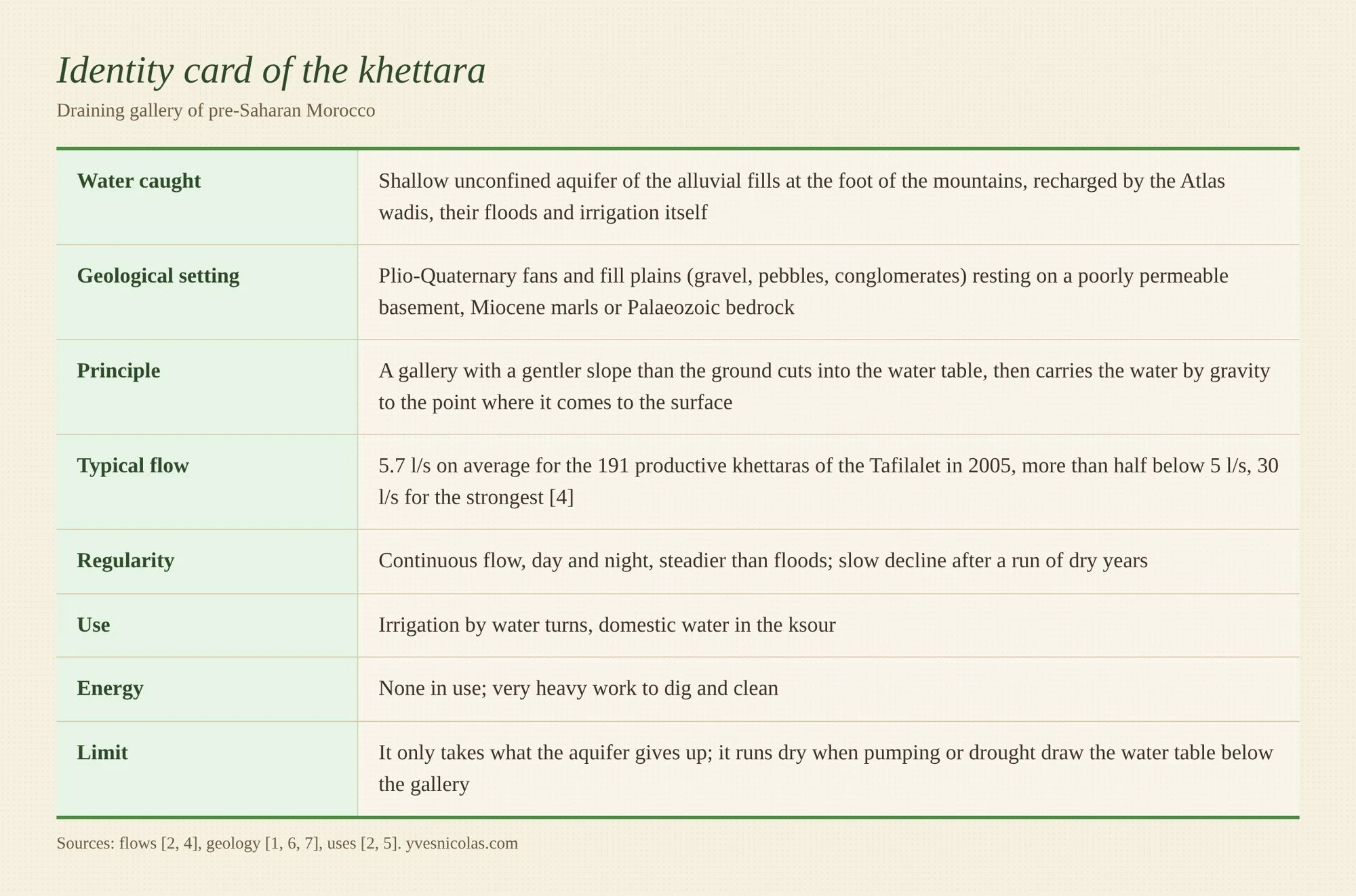
1. The bedrock: why the water is there
A khettara only works if three geological conditions come together: a permeable reservoir, a watertight floor that keeps the water close to the surface, and a ground slope steeper than that of the water table. This is why they are found at the foot of mountains, the High Atlas, the Anti-Atlas, the Jbel Bani, and never in the middle of an open plain.
The reservoir, first of all, is made of the debris of the Atlas. As the range wore down, it poured masses of gravel, pebbles and sand onto both of its foothills. In the Haouz, these Mio-Plio-Quaternary deposits form large alluvial fans, born of the dismantling of the range [6]. In the Tafilalet, the plain is a Quaternary fill 15 to 30 m thick [1]. These materials are very mixed: the water moves through lenses of coarse gravel, which form true underground corridors [3].
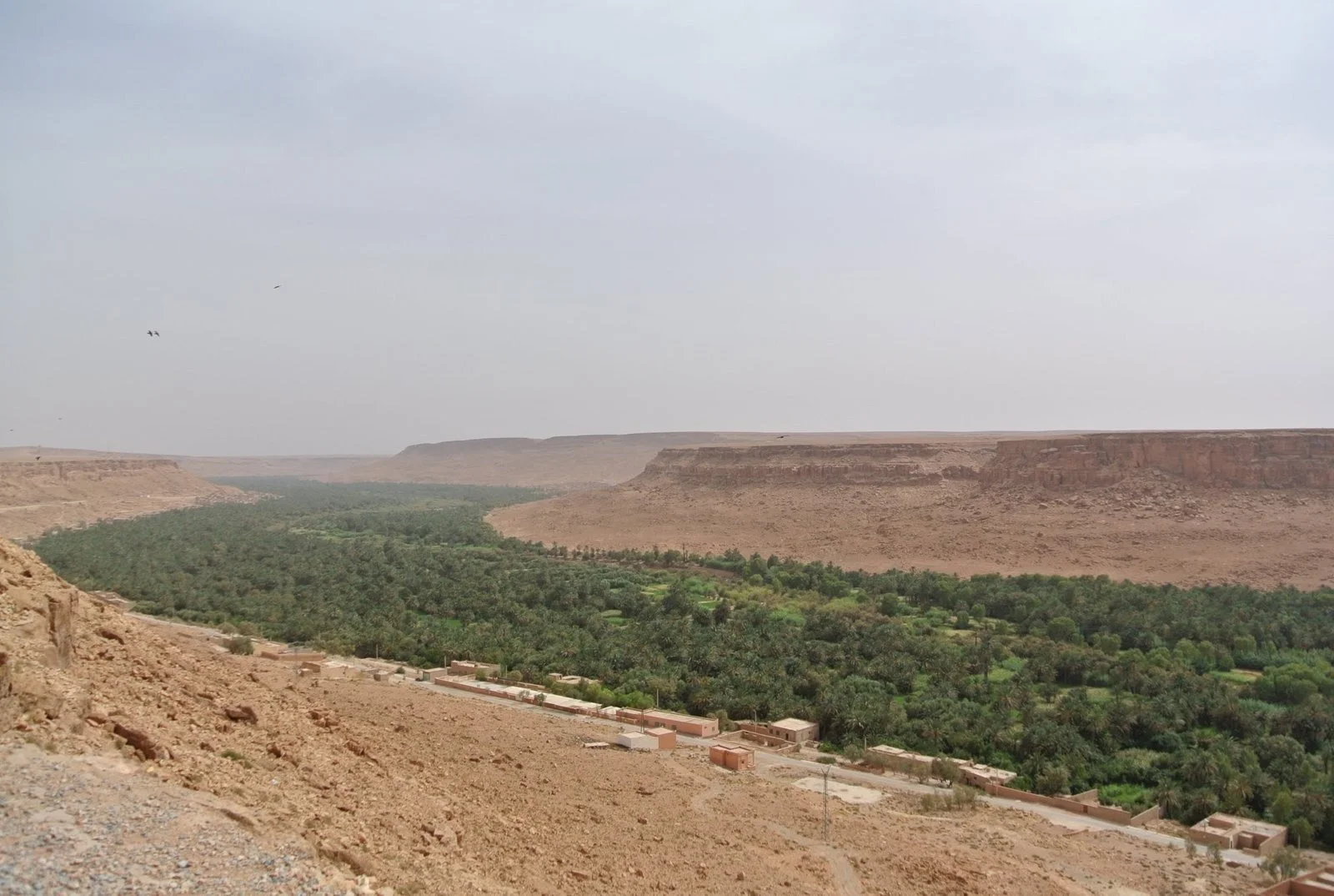
Ziz valley: a ribbon of palm grove at the bottom of the valley, where the water table comes close to the surface. Photo Ben Bender, CC BY-SA 3.0.
Under this reservoir there must be a floor: a rock that does not drink. In the Tafilalet, the alluvium rests on an almost impermeable Palaeozoic basement [1]. The aquifer is no more than 21 m thick there, 6.3 m on average, and its top lies on average 6.5 m below ground at low water [1]. An aquifer this thin and this close to the surface is within reach of a pickaxe, and it is the one the khettara drains.
A slope is also needed. On an alluvial fan, the ground falls faster than the surface of the water table. A gallery dug with an even gentler slope than the ground therefore ends up coming out into the open air, downstream, with the water it has gathered upstream. Without this difference in slopes, one would have to pump.
As for the strength of the galleries, it comes from a limestone crust. In the Haouz, most khettaras are dug in the Plio-Quaternary fans on both sides of the Tensift [7]. This crust, the calcrete, covers much of the alluvium there. The classic galleries, marked out by shafts, were dug beneath this crust, which serves them as a natural vault and has protected them for centuries [7]. Where the water table is almost at the surface and the soil is loose, one finds instead open trenches without shafts, which the authors take to be the oldest form [7].
This water comes from the mountains. In the central Haouz, recharge measured in 2011-2012 ranges from 13 to 100 mm a year, that is 3 to 25 % of the rainfall, and peaks under the Ourika basin [6]. In the Tafilalet, local rain hardly counts. The aquifer lives on the floods of the Ziz and the Rheris, and the Ziz alone brings 60 to 600 million m³ a year depending on the year, although it flows on average only about 25 days a year [1]. In 1961 Jean Margat added a fact that is often forgotten: without the irrigation water that seeps back into the ground, recharge would fall by two thirds. This aquifer is largely a product of irrigation [1]. A 2024 study of the Errachidia basin takes the question up again with hydrochemical and isotopic tracers, to pin down the recharge processes and how long the water stays underground [32].
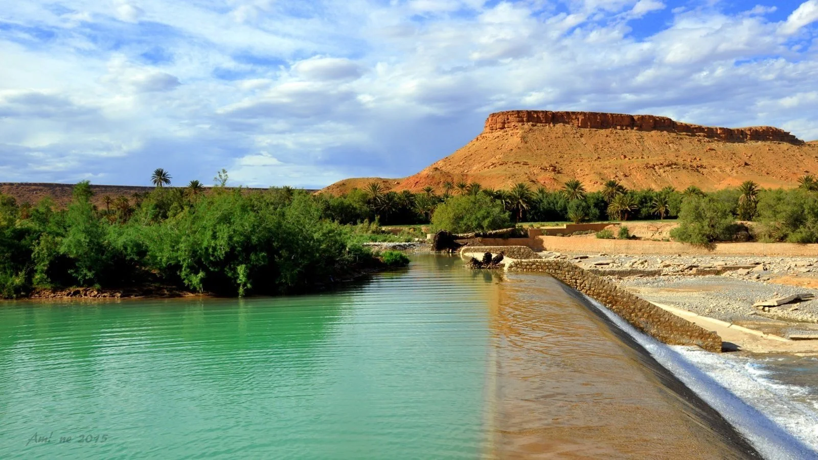
The Gheris at Goulmima: the wadi whose floods feed the khettaras' aquifer. Photo Amine Bahdod, CC BY-SA 3.0.
In the Ferkla, between Tinejdad and Goulmima, the picture is even drier: about 125 mm of rain and 2,930 mm of evaporation a year at the nearby Ait Bouijane station [5]. The northern khettaras there drain an infra-Cenomanian aquifer fed by the High Atlas, those in the centre a Quaternary aquifer fed by the Tanguerfa wadi, and surface water only arrives in flood [5].
In a closed plain, water ends up loaded with salt. In the Tafilalet, it is sodium chloride. The most frequent salinity class is 2 to 3 g/l, but over three quarters of the aquifer's extent the water exceeds 3 g/l, and Margat put the salt accumulating there at about 30,000 tonnes a year [1]. One would expect a khettara to draw sweeter water the higher it reaches up the fan, where recharge arrives. The ORMVA analyses in the Fezna, Jorf and Hannabou area say the opposite: khettara water there carries on average 1.95 g/l of salt, and the content falls from upstream to downstream, because the northern aquifer, which runs along the Gheris, and the south-western one, where the galleries draw, do not hold the same water [48].
2. The structure: four sections, four functions
A khettara reads from upstream to downstream as a series of sections, each with its role in catching or carrying the water; the Japanese report distinguishes five, which I reduce here to four [2].
The first is the catchment section. At the head, the gallery passes below the top of the water table. Water seeps from the gravel and sand through the walls and the floor, and the stream is born there. It is the only section that catches water. In some basins, the gallery is dug under the bed of the wadi, collecting its underground flow [2].
Next comes the conveyance gallery. Further down, the water table drops below the floor. The gallery no longer catches water, it carries it, and it loses some: this is where water seeps into the gravel [2].
Then the channel, open to the sky at first. Where the gallery is less than 3 m below the surface, it is now covered with stone or concrete slabs against the sand [2].
Finally the outlet and the domestic intake. The gallery comes out into the open, often near the ksar, where a concrete channel provides water for drinking and washing, before the basin and the seguias of the gardens [2].
Slope is the whole science of the structure. The draining gallery falls by 0.05 to 0.15 %, that is half a millimetre to a millimetre and a half per metre, always less than the slope of the water table [8]. In the Fezna-Jorf-Hannabou sector, the water table itself falls by about 0.2 % [8]. It is this small gap, of the order of a millimetre per metre, that brings the gallery back up towards the surface over the kilometres. Too much slope, and the water eats away the floor; too little, and silt settles in it.
In the Tafilalet, according to the ORMVA, the draining gallery runs between 10 and 20 m deep, 0.35 to 0.60 m wide and 1.20 to 2.00 m high [8]; the Japanese report gives more modest depths, generally 2 to 10 m, 18 m at most [4]. The Japanese inventory records even narrower galleries, 0.3 to 0.4 m wide and 0.8 to 1.2 m high, where a man moves bent over and sideways [2]. Head shafts can reach 40 to 50 m in the Haouz, where the water table was deeper [8], whereas in the north of the Tafilalet a few metres were enough to reach water [9].
A shaft is dug every 10 to 15 m in loose ground and every 20 to 30 m in firm ground [8]. They are used to bring up the spoil, to air the workings, then to go down for cleaning. Around each one, the spoil forms a ring of earth that protects the opening from runoff: these are the lined-up “molehills” that can be followed on aerial images.
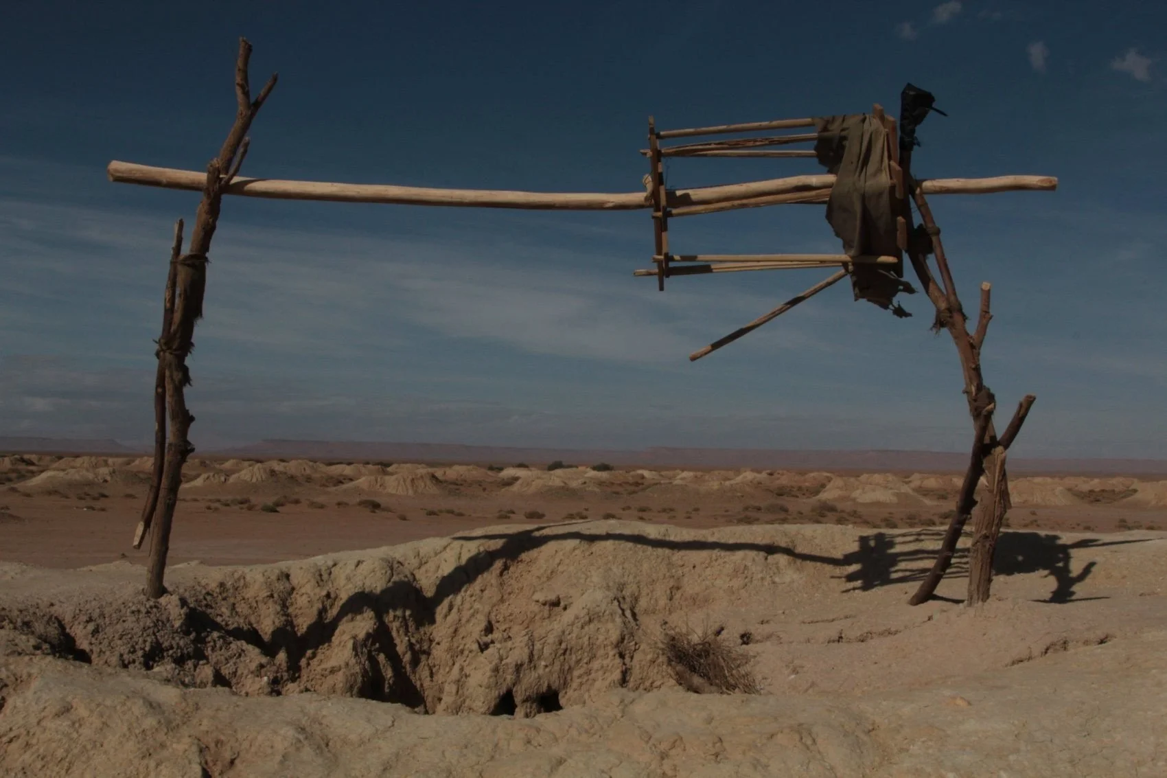
Khettara shafts in the Tafilalet: the wooden frame is used for cleaning, the spoil heaps line up to the horizon. Photo Sebastian Lapostol, CC BY-SA 4.0, via Wikimedia Commons.
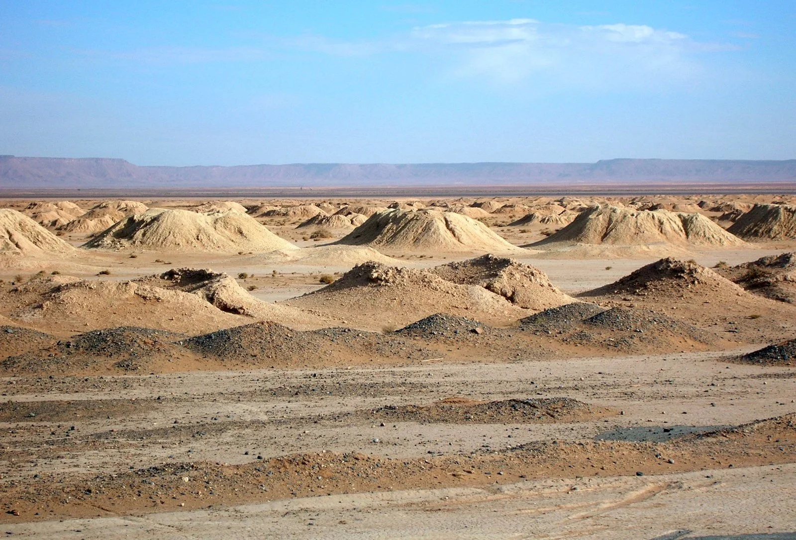
The spoil cones mark out the gallery for kilometres. Photo Bernard Gagnon, CC BY-SA 3.0.
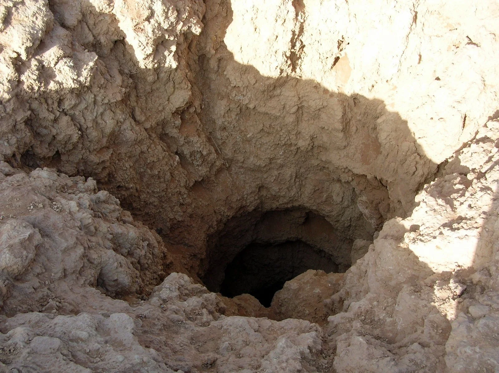
A shaft seen up close: the opening through which one goes down to clean. Photo Bernard Gagnon, CC BY-SA 3.0.
The 410 khettaras inventoried in 2003-2005 in the eastern south-Atlas region, the Tafilalet plain and neighbouring basins, add up to 1,312 km of galleries, 3.2 km on average; in the Jorf, Fezna and Hannabou area, the average rises to 5.6 km [2]. Another figure is often quoted, 570 khettaras and 2,900 km of galleries for the Tafilalet, repeated in ORMVA notes [48] and even in the press. The JICA report explains it: it comes from the 1967 census, which counted everything, including galleries already abandoned; since then, 160 of them have been left to ruin, and the 2005 inventory kept only 410, 191 of them with a confirmed flow [2]. The two numbers describe the same region forty years apart. In the Ferkla, 29 khettaras, ten of them dry, total about 74 km, or 2.6 km each [5].
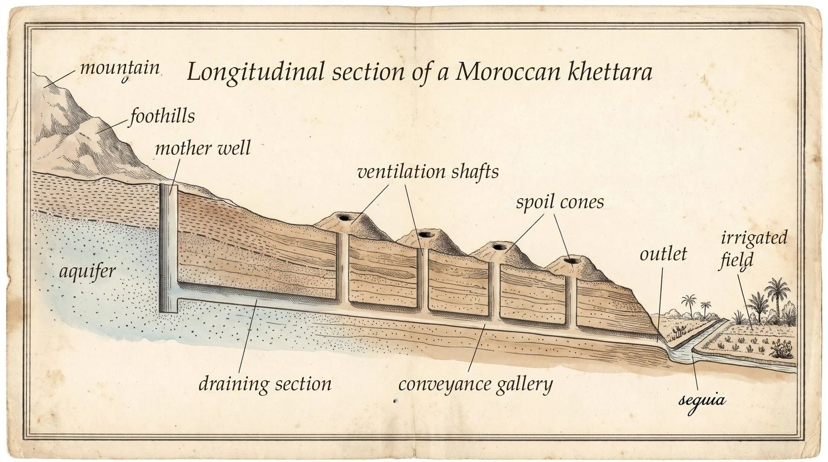
Cross-section. Khettara: from the mother well to the seguia, water flows on its own beneath the foothills. AI engraving.
3. Flows and regularity
A khettara gives little, but all the time: a few litres per second, day and night, all year round. At the beginning of 2005, the 191 khettaras still active in the area of the ORMVA of the Tafilalet together delivered about 1.1 m³/s, or 5.7 l/s each on average [2].
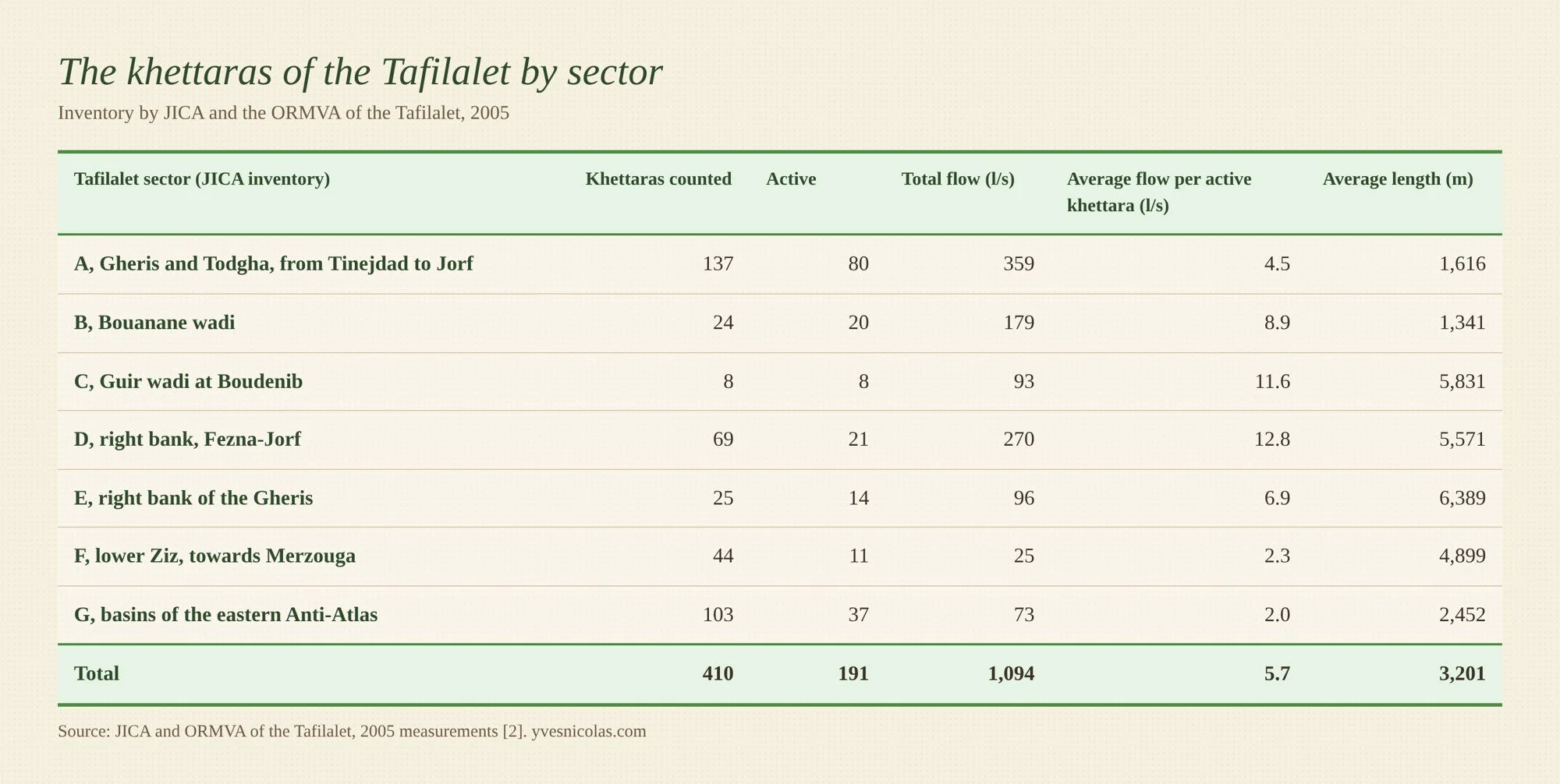
These 1.1 m³/s amount to about 35 million m³ a year. This is close to what the Hassan Addakhil dam, upstream on the Ziz, released in a dry year: 26 million m³ in 2002, for an average stored volume of 71 million m³ since 1971 and a useful capacity of 350 [2]. The comparison is rough, since a stock is not a flow and the dam also serves to cut flood peaks, but it shows that galleries dug by hand weigh in the water balance of the plain. The khettaras of the Haouz gave much more: in the 1970s, 606 galleries irrigated about 20,000 ha there with 3,200 l/s according to the Japanese report [4]; according to Pascon, quoted by El Faiz and Ruf, there were rather 567 galleries, 500 of them flowing, and 5,059 l/s [45].
Margat had given this flow its true measure. In the Tafilalet, he wrote, a million cubic metres a year supports three to four people per hectare when it comes from floods, and nearly fifteen when it is a perennial flow [48]. The water of a khettara is worth four to five times that of a flood, because it arrives every day.
In October 2003, in the Tafilalet, more than half of the active khettaras, 55 %, delivered no more than 5 l/s; the most generous of all, that of Haj Allal, gave 30.2 l/s [4]. In the Ferkla, flows range from less than 1 to 19 l/s [5]. The longest and deepest khettaras, which reach for water high up on the fan, are generally those that give the most [8].
Regularity nevertheless has its limits. The flow does not depend on the day's rain, but on the state of the aquifer. Measurements repeated in June 2003, September 2003 and February 2004 show three types of behaviour [3]:
First there is the stable khettara, fed by a well-stocked aquifer, whose flow barely changes from one survey to the next: this is the case for the galleries of the Jorf and Fezna areas.
Then there is the one that responds to floods, when the gallery runs along a wadi bed: its flow leaps in the days following the September flood, then falls back.
Finally there is the one that dies out, on a falling aquifer, like the galleries of the Reg, dry from May to October.
Over the long term, the trend is downward: total flow fell from 1,277 l/s in 2001-2002 to about 1,100 l/s in 2005, the report giving 1,124 l/s in its text and 1,094 in its table by sector, about 12 % less, and the southern zones (E, F and G) lost 62 to 76 % of their flow [2].
In the conveyance gallery, water leaks into the gravel: 1.6 l/s per kilometre on average, over about 60 % of the length of the galleries [2]. The 1998 ORMVA report puts the average efficiency of a khettara at 60 %, with losses in the conveyance section reaching 30 to 50 % of the flow caught upstream [8]. We shall see further on that these losses are not all lost.
4. The khettara's role in the water cycle
The khettara is part of a loop: the flood fills the aquifer, the gallery gently empties it, irrigation returns part of it to the aquifer, and the palm grove takes some back directly through its roots.
A gallery only drains the water lying above its floor. If the water table falls, the flow falls with it, then stops: the structure cannot go down to fetch water lower, as a pump does. Against boreholes, this is its weakness; but by its very design it only takes the overflow of the aquifer, what the aquifer gives up of its own accord downstream. The limit appears when the gallery is extended upstream, or the mother well is deepened to follow a falling water table: the khettara then draws on the aquifer's stock, like a borehole, only more slowly. The Japanese report notes that it withstands drought better than surface water and loses little to evaporation, since the water travels underground [4].
The 1.6 l/s lost per kilometre of gallery [2] do not evaporate: they return to the gravel and to the aquifer, downstream, where other wells and other khettaras take them up again. The same goes for irrigation water seeping under the basins: in the Tafilalet, it provides two thirds of the aquifer's recharge [1]. The only real losses in volume, for the basin, are evaporation and transpiration. In quality, it is another matter: water that seeps in picks up salt, and what reaches a salty aquifer downstream is lost for use. Lining the whole gallery with concrete improves the flow at the outlet, but deprives the downstream area of recharge.
The balance drawn up by the ORMVA for the Fezna, Jorf and Hannabou aquifer puts figures on this loop. Of about 25 million m³ entering each year, 11 come from flood spreading on the fields, 43 %, 12 from underground flow from upstream and 2 from seepage in the wadi bed. On the other side, 11 million leave downstream underground, 8 are pumped, and the khettaras take only 3.7 [48]. The gallery is the smallest of the users; flood spreading, often seen as waste, is the largest of the providers.
The palm grove, too, drinks from the aquifer. In a Tafilalet palm grove where the water table lies at 4 or 5 m, the date palm (Phoenix dactylifera) can send its roots down to 9 m, and during a fifteen-day halt in watering in midsummer, the aquifer supplied it with nearly half of its transpiration [10]. The palm grove and the khettara therefore draw from the same reservoir: one through the gallery, the other through its roots. One hypothesis can be drawn from this, which the study does not test: this biological pumping may help keep the water table low enough to limit the rise of salt.
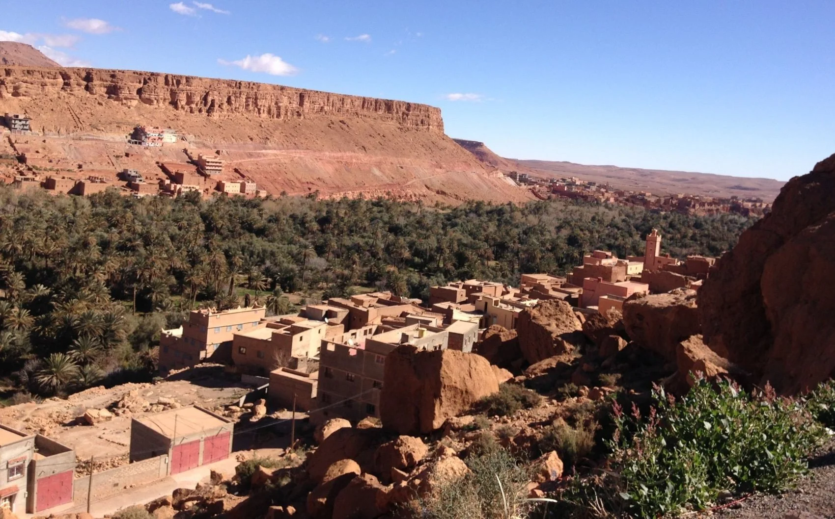
xThe palm grove at the foot of the cliff: building stops where the irrigated land begins. Todra valley, January 2019. Photo Yves Nicolas.
The water caught carries its salts away, which irrigation concentrates and then sends back to the aquifer. Across the Tafilalet plain, about 30,000 tonnes of salt accumulate downstream each year [1]. A khettara does not export salt out of the basin: it moves it.
To set an order of magnitude, let us start from the published figures. An average Tafilalet khettara delivers 5.7 l/s [2], about 180,000 m³ a year. A twelve-year-old Majhoul date palm needs about 50 m³ a year under drip irrigation at full ration, 44 m³ with the reduced regime recommended by the trials carried out at Goulmima [11]. On paper, an average khettara would thus cover the needs of about 3,500 drip-irrigated palms. But the khettara irrigates by flooding, and for this method the FAO gives 13,000 to 20,000 m³ per hectare per year in Morocco [30]: the same khettara then waters 9 to 14 ha. In a real oasis, the water also serves the fruit trees and the ground crops, the basins lose a share, and the aquifer tops up the palms' ration. Lightfoot estimates that the 80 or so historic khettaras of the Tafilalet oasis proper irrigated about 3,000 ha [9]; in the Haouz, 3,200 to 5,000 l/s served 20,000 ha [4, 45], that is 5,000 to 8,000 m³ per hectare per year. This calculation only gives a scale: to my knowledge, no complete and measured water balance of a khettara palm grove has been published, following at once the flow, the losses, the recharge, the evapotranspiration and the salt.
5. Digging and upkeep
Digging starts downstream. The work begins at the outlet, whose level is set by the plots to be irrigated. First a trench is opened, which becomes a gallery when it goes deeper than about 4 m [8]. Then a shaft is sunk upstream, and two teams advance towards each other, from the head of the trench and from the bottom of the shaft. The spoil comes up in a basket, at the end of a rope, by a wooden windlass, and piles up around the opening [8]. Starting downstream has a simple reason: the gallery always stays dry behind the worker, and any water he meets drains away by itself towards the outlet.
A khettara costs little in money and a great deal in labour. The 1998 ORMVA report gives the example of a 4 km gallery, with shafts no deeper than 12 m, dug by 40 men in four years [8]. Paul Pascon estimated that about 300 working days are needed per litre per second obtained for a small khettara, and up to 1,500 for a large one; for the Tafilalet khettaras, of 5 to 20 l/s, the report retains about 750 days per litre per second [8]. An average khettara of 6 l/s therefore represents something like 4,500 working days.
In the Tafilalet, upkeep was historically carried out by the haratin and by specialist well-diggers, the khattater; today, each family of the ksar provides a worker in turn, and neighbouring ksour sometimes lend a hand for money or a service in return [9]. In 1992, a worker's day paid from public aid was worth about 30 dirhams [9].
Sand and earth come in through the shafts and through falls from the walls, and cleaning cannot be avoided [2]. Under the rule described by the ORMVA, upkeep, or attahjir, is organised by the sheikh of the khettara and his mezregs: each rights holder owes one worker's day per nouba per week, so that a khettara of 30 noubas mobilises about four men a day to clean, unblock and seal [8]. Rights holders meet on Friday after prayers to decide on the work, and a fund of 100 dirhams per nouba pays for masonry and extensions [8].
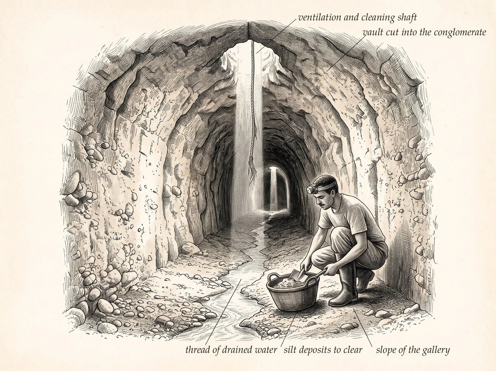
Inside a khettara: the gallery cut into the conglomerate, the thread of drained water and the column of light from a cleaning shaft. AI engraving.
One goes down the shafts, brings the mud up in baskets, clears the falls, and deepens the mother well or the intermediate shafts when the water table has dropped [9]. Lengthening the gallery upstream to reach a lower water table is the traditional answer to a falling flow; it has a limit, when the gallery reaches the foot of the mountain or a layer too hard to dig.
Earthquakes, floods pouring into the shafts, collapses, and even the use of dynamite for cleaning have damaged galleries [9]. A poorly protected shaft becomes the funnel of a flood, which fills the gallery with mud in a single night: hence the ring of spoil around each opening, and today the raised kerbs and protective walls [2].
6. History and distribution
The khettara is the Maghrebi form of the qanat, born on the Iranian plateau. Its route to Morocco is still debated. According to a text by al-Idrisi, around 1107 the Almoravid emir Ali ibn Yusuf entrusted the Andalusian engineer Abd Allah ibn Yunus with organising the water supply of the Haouz of Marrakech [12]. Paul Pascon objected in 1977 that the technique had long been known throughout the western Sahara, and that it is hard to see an engineer introducing what already existed just south of Marrakech [12]. In 1983, from two Arabic texts of the 9th and 11th centuries, Miquel Barceló showed that the qanat was known in al-Andalus as early as 753-754; the word khattara may already be used there, and majra refers to the water catchments of the Madrid of the emirs [12].
In al-Andalus, galleries ran beneath the towns. In Madrid, galleries identified as qanats in 1959 were linked to the Muslim foundation of the city, and others have since been found in the centre of the peninsula [13]. This origin is still debated: it rests mainly on the work of Jaime Oliver Asín, and the great viajes de agua that supplied the city, Amaniel, Fuente Castellana, Abroñigal, date from the early 17th century [31]. So one cannot say that the khettara was imported from one side or the other: the principle was known on both shores of the strait, and each era took it up and enlarged it to suit its needs.
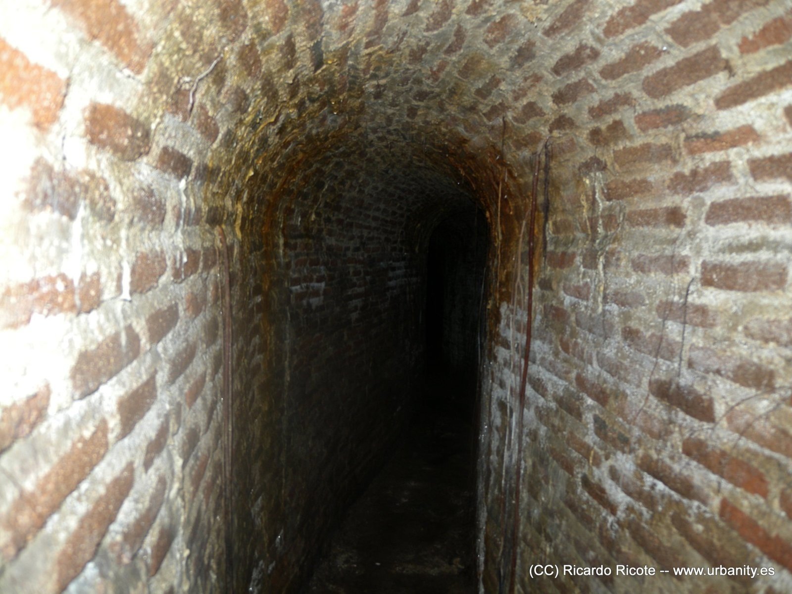
Gallery of the Amaniel viaje de agua, Madrid: the khettara principle beneath a European capital. Photo Ricardo Ricote Rodríguez, CC BY 2.0.
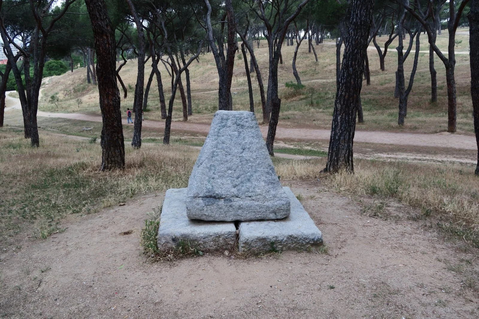
The capirote, the stone cover of a viaje de agua shaft, Madrid's equivalent of the spoil cones. Photo Malopez 21, CC BY-SA 4.0.
In the Tafilalet, the network is late. According to Dale Lightfoot, the Tafilalet network was dug from the end of the 14th century, after the collapse of Sijilmassa: about 80 khettaras, 300 km of galleries, serving 28 of the 132 ksour of the oasis, all in the north of the plain [9]. Some galleries in the Sifa district may date only from the 1730s [9].
Khettaras follow the foothills where the three geological conditions of section 1 come together.
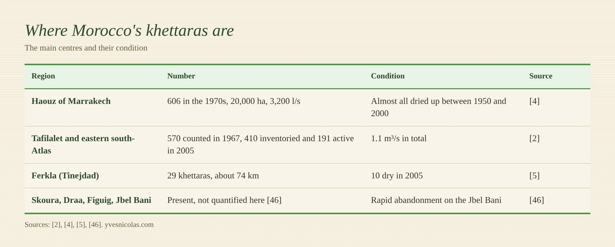
7. Society: who has a right to the water
The water of a khettara belongs to those who dug it. In the Tafilalet, rights were first shared out according to each person's contribution to the construction, and they are passed on by inheritance, divided, sold, bought and rented [4]. Lightfoot specifies that each share depended on what had been contributed: land, labour, tools and money [9].
The whole flow of the khettara passes from one rights holder to the next, and the basic unit, the nouba, is worth 12 hours of water. The full cycle of the water turn lasts 4 to 26 days depending on the khettara [4]. It is a sharing of time, unlike the Algerian foggara, which shares the flow continuously through a comb.
Each khettara has its group of rights holders, which itself pays for cleaning and repairs [4]. A sheikh of the khettara and his mezregs organise the weekly upkeep and watch over the turns [8]. These customary rules, the orf or azref, protect the structure and set its use. One simple rule holds the whole edifice together: the right to water requires a share of the work. Whoever does not clean gradually loses his place.
Private boreholes, since the first diesel pump was installed in the Tafilalet in 1965, undo these bonds: everyone can now have his water without the others [9]. In the Ferkla, the arrival of solar pumping to top up the khettaras has changed the rules [5]. At Ait My Mamoun, rights have been reserved for permanent residents. At Izilf, the 24-hour turns have been kept, but the day and night slots alternate from one turn to the next, so that everyone benefits from the water pumped by day. Elsewhere, extra days of water are rented to people without rights, and this income pays for upkeep. Finally, a sluice at the junction of gravity water and pumped water reserves the latter for those who pay their share.
The khettara is an institution as much as a structure: when the group falls apart, the gallery silts up.
8. Decline and threats
A khettara rarely dies of wear; it dies when the water table drops below its gallery. The causes of that drop are known, and they add up.
In the Tafilalet, the first private diesel pump was installed in 1965; some thirty years later, Lightfoot counted nearly 750 private wells fitted with pumps [9]. In the Fezna, Jorf and Hannabou area alone, at the beginning of the 2000s, the ORMVA recorded nearly 200 pumping stations drawing 8 million m³ a year, and 65 % of the 60 khettaras dried up; those of Fezna and Achouria, upstream, were all dry, those of Jorf partly, and those of Bouya, Krair and Hannabou still flowed, weakly [48]. In the Ferkla, irrigated extensions outside the oasis grew from about 1,580 ha in 1984 to 3,730 ha in 2021, and solar pumping stations, in the Todgha and Ferkla region, from about twenty in 2013 to more than 180 in 2020; the ORMVA counts 415 in operation [5]. Drinking water boreholes complete the picture, and a farmer at Ait Oulghoum dates the faster decline of his khettara to 2010, after those installed upstream came into service [5]. A pump goes down to fetch water where the gallery cannot go: each metre of drawdown shortens the catchment section by as much, until it disappears.
The Tafilalet aquifer lives on the floods of the Ziz and the Rheris [1]. Since 1971, the Hassan Addakhil dam has held back the Ziz and releases it only three or four times a year, for 20 to 23 days, each village receiving 10 to 12 hours of water [9]. Fewer floods in the bed means less recharge under the plain: the dam that secures surface water eventually leaves the galleries thirsty.
The Japanese report puts first among the causes the drought that has lasted since 1997 and reduces recharge [4]. Between 2001-2002 and 2005, the total flow of the khettaras of the eastern south-Atlas region fell by 12 to 14 %, and by 62 to 76 % in the downstream sectors [2].
Yet the water table can rise again. According to Abdennabi El Mandour, director of the Mohammed VI Museum of Water Civilisation in Marrakech, the return of heavy rains between 2009 and 2013 on the south-eastern slope of the High Atlas raised the water tables and brought large flows back into the khettaras, to the benefit of the crops and the economy of the oases [29]. He concludes that artificial recharge of the alluvial aquifers along the wadis is one of the ways to save these structures, and points out that with a khettara, abstraction never exceeds natural recharge [29]. A dry khettara can therefore come back, if the water table rises again under its gallery. The torrential rains of late August and September 2024 in the south-east of the Atlas [33], then those of winter 2025, which brought the reservoirs of the Guir-Ziz-Rheris agency to 53 % full in March 2025 against 19 % a year earlier [34], offer a new test, but I know of no published measurement of khettara flows after these rains.
The same report cites insufficient upkeep, for lack of labour, silting and flood damage [4]. The end of the labour obligations that weighed on the haratin also deprived the khettaras of those who cleaned them [9].
In the Haouz, the khettaras dried up, with a few exceptions, between the 1970s and the 2000s, because of over-pumping of the aquifers [4, 45]. In the Tafilalet, only 19 of the 80 or so historic khettaras remained at the beginning of the 1990s according to Lightfoot [9], and 191 of the 410 galleries inventoried across the eastern south-Atlas region were still flowing at the 2003 inventory [4]. The 2022 study on tourism adds a less measurable factor: a loss of interest in these structures among part of the population [14].
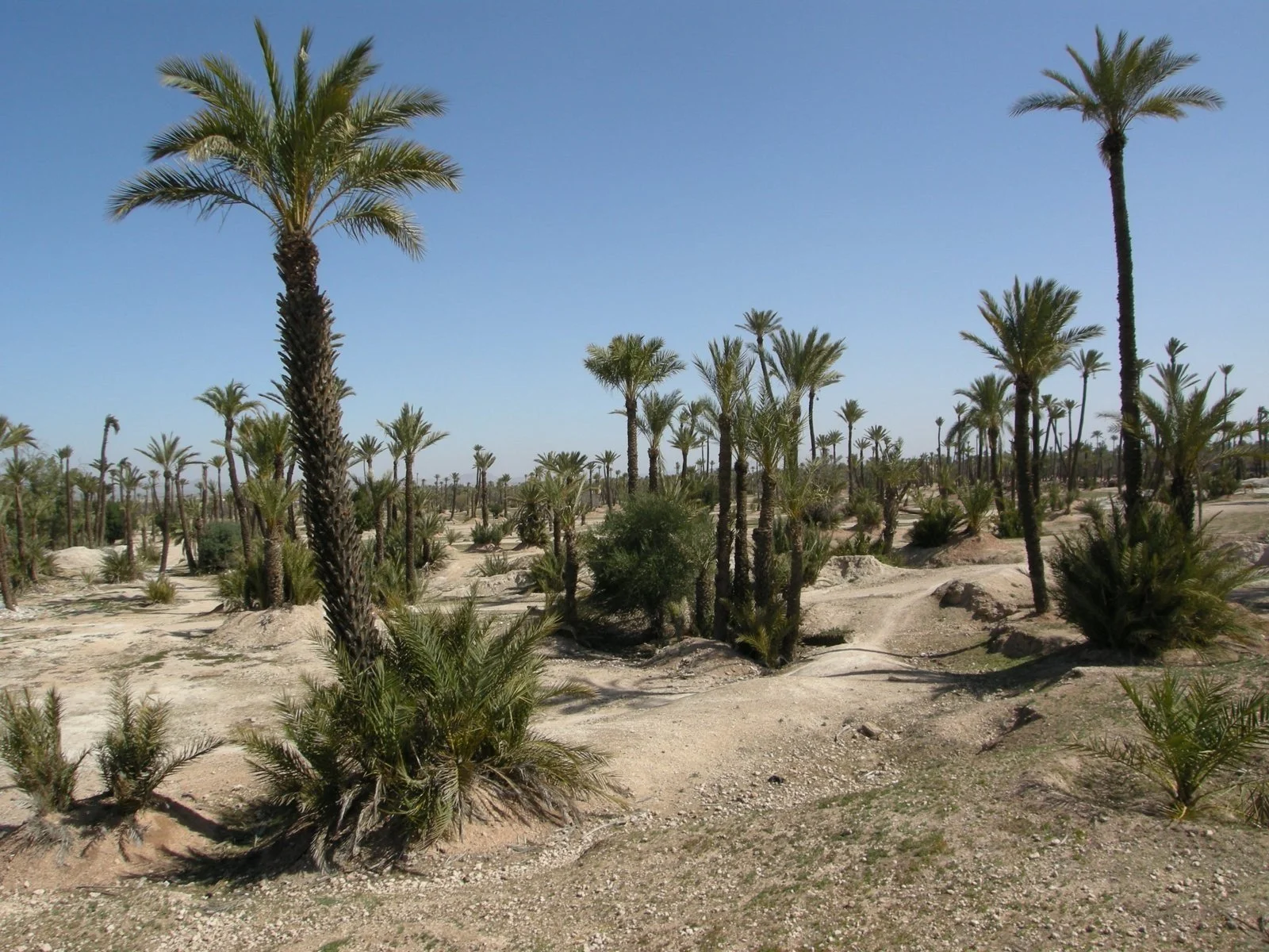
The palm grove of Marrakech: palms on bare soil, between the mounds of dried-up khettara shafts. Photo Alex, CC BY-SA 3.0.
9. Restoring and managing them today
Restoring a gallery is useless if the aquifer that feeds it keeps falling. The programmes carried out over the past thirty years show this: we know how to repair the structure, we know much less about protecting its source.
The ORMVA of the Tafilalet treated about 200 khettaras in nine years, for about 110,000 dirhams each, with a budget line of 22.1 million dirhams between 1995 and 2002 [2]. The work covered 59.4 km of galleries, 4.5 % of their total length: reshaping, extension upstream, masonry or concrete lining, slab covers, PVC pipes of 200 to 400 mm in the leaking gravel, flood walls and raised kerbs [2]. The Japanese report quantifies no gain in flow from this work, and considers it hard to predict the effect of an extension without a hydrogeological study [2]. The Tafilalet Oasis Programme, run from 2006 to 2016 with UNDP, also restored khettaras, Omaria in 2011 and Litama in 2013, and marked out the Majhoul Route, a tourist trail [47].
In the Ferkla, since 2020 solar pumps have been injecting well or borehole water into the khettara, at the head of the traditional basin, sometimes after storage in a basin of 1,200 to 2,200 m³ to deliver an almost constant flow over 24 hours [5]. The system saves collective access to water in the short term, but the authors warn that it adds to the drawdown of the aquifer and will not guarantee the survival of the khettaras without regulation of abstraction [5]. It pumps from the very aquifer the gallery drains.
What remains is what is missing, and what can be done. The sources converge on six conditions, which serve as a diagnostic grid in the field.
First point: protect the aquifer upstream. A perimeter where boreholes are limited, around the catchment section, matters more than all the concrete in the gallery. The Ferkla study calls for rules of access to the aquifer that apply to everyone [5]; the perimeter is the form I propose for them.
Second point: recharge. The aquifer lives on floods and irrigation [1]. Letting floods spread out and seep in upstream, through weirs and spreading works, directly feeds the gallery. Trials already exist in the region: harvesting floods to recharge the aquifer of a date farm [35], and a survey of the willingness of the farmer groups of Todgha and the Ferkla to install recharge works [36].
Third point: do not seal the catchment section. Only the conveyance gallery should be lined, and only where the lost water benefits no one downstream; elsewhere, the leaks recharge other people's aquifer.
Fourth point: measure. A flow reading taken every month at the outlet and a piezometer at the head of the gallery tell better than anything whether the resource is holding. The Japanese report rightly regrets being unable to quantify the effect of the work [2].
Fifth point: keep the institution alive. Water rights, a share of the work, an upkeep fund: without the group of rights holders, the restored structure silts up again [4, 8].
Last point: water better at the end of the gallery. Every litre saved in the field, through levelling, mulching or irrigating by tensiometer, leaves water in the aquifer, provided it is not used to irrigate new land.
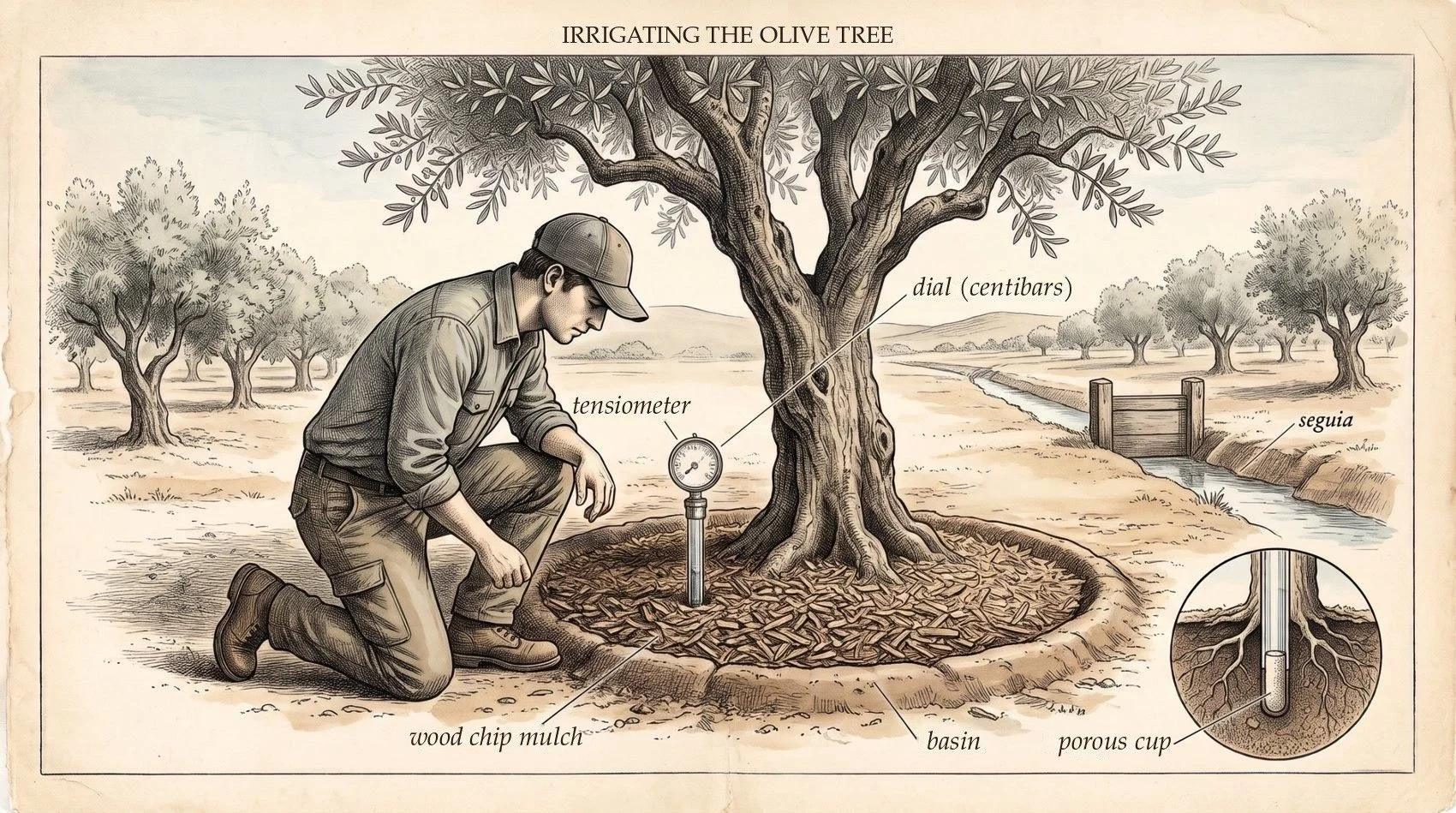
Measure before watering: the tensiometer, not the calendar, tells when to open the seguia. AI engraving.
To my knowledge, no study follows a restored khettara over several years, measuring at once its flow, its aquifer and the neighbouring boreholes. Yet it is the only way to know what a restoration is worth.
10. What the khettara teaches us today, and what that is worth
Digging new khettaras hardly makes sense any more: at about 750 working days per litre per second [8], and on aquifers already drawn down, the sums do not add up. Its principles, however, speak directly to today's water problems in Morocco. The first two are developed below; the others appear in a table ranked by relevance.
First lesson: we can only preserve the water whose flow we know
Khettara society lived on a flow known to all. The water comes out in a single place, in sight of the ksar; everyone sees what it gives this year, and the nouba shares that flow among the rights holders [4]. When it falls, everyone sees it on the same day, and it is the group that decides to clean, to lengthen the gallery or to reduce the cultivated area. The principle fits in a few words: we only share, and therefore only preserve, what we measure.
The flow of the khettara also tells the state of the aquifer. The 2003-2004 readings distinguish at a glance the aquifer that holds, the one that responds to floods and the one that is running out [3]. It is a free measuring instrument, already in place, working day and night.
A network of khettaras is thus the barometer of the balance between what the aquifer receives and what we take from it. Set against the year's floods, it becomes the witness of our overconsumption: if the flow falls when floods have been normal, it is abstraction that is speaking. Each gallery reads the aquifer along the whole length of its catchment section, several hundred metres, where a piezometer only sees a single point. Springs play the same role: after the rains of winter 2025, Ain Meski, the blue spring of the Ziz valley, began flowing again after more than three years dry [34].
This barometer has four limits, which one must know to read it correctly. It confuses drought and pumping as long as it is not set against the year's recharge. It stops at zero: a dry gallery no longer tells whether the water table is one metre or twenty below its floor. Upkeep distorts the reading, since a silted gallery delivers less without the aquifer having moved, and a lengthened gallery hides the decline. Finally, it only sees the shallow aquifer: if boreholes pump a deeper and poorly connected aquifer, the khettara can remain stable while that one is being exhausted. To make it a public indicator, three readings must therefore be kept together: the monthly flow at the outlet, the year's floods or rainfall, and the work done on the gallery.
It is this knowledge that is missing today. In the Ferkla, the basin agency has authorised about 200 pumping stations, whereas the ORMVA counts 415 in operation [5]: no one knows how much the aquifer really gives, nor how much is taken from it. In Morocco, about half of the aquifers are thought to be overexploited, with access to boreholes mostly individual and poorly controlled [18]. The lesson of the khettara comes down to three actions: a meter on every borehole, regular readings of the flow of the khettaras still active as a witness of the aquifer, and authorised volumes that stay below the measured recharge.
Second lesson: preserving the oasis means banning the boreholes that ruin the existing structures
In a khettara oasis, a borehole dug deeper, often upstream, takes the water before the gallery: the structure stops while the water is still there, lower down. In the Ferkla, a farmer at Ait Oulghoum dates the collapse of his khettara to the opening of drinking water boreholes upstream [5]. In the Tafilalet, the 750 or so wells fitted with pumps counted by Lightfoot went hand in hand with the disappearance of most of the galleries [9]. In the Haouz, the khettaras almost all dried up within half a century [4, 45]. The mechanism is always the same: the borehole draws the water table below the floor, and the structure that served a whole ksar stops for the benefit of a few plots.
Tradition already had the rule. Islamic law recognises around a well, a spring or a channel a harîm, a protected zone where no one may dig a new well that would harm the first [15]. The Maliki school, that of Morocco, sets no uniform distance: it makes it depend on the nature of the ground, the size of the well and the number of its users [15]. Here, a thousand years ahead of its time, is a hydrogeological criterion: the zone to be protected depends on the way water moves through the ground.
Modern law has the tools. Water law 36-15 provides for safeguard and prohibition perimeters, and its implementing decree, which governs authorisations inside these perimeters, was adopted by the Government Council on 6 February 2025 [16]. The tool is not theoretical: a safeguard perimeter was already drawn in the Chtouka plain in 2017, with a declared state of water shortage, a halt to authorisations for any irrigated extension, compulsory sealed meters, quotas and the regularisation of undeclared abstraction [42]. The law also provides protection perimeters around catchments of water intended for public supply [16], and it excludes from the public domain the waters over which historical rights have been duly recognised [17], which may be the case for the water rights of khettaras.
I draw a proposal from this: classify as a prohibition perimeter the supply zone of each khettara still active, that is the catchment section and the aquifer upstream of the mother well, over a width set by the hydrogeology of the site, as the Malikis wanted. No new borehole would be authorised there; existing boreholes there would be fitted with meters and capped. A khettara that supplies the fountains of a ksar could also fall under the protection perimeters of public catchments. These two avenues still need to be checked legally, case by case, with the basin agency. A ban alone will not be enough without control: the gap between 200 authorised stations and 415 in operation in the Ferkla shows it [5].
The mirror of Oman and Iran: the harîm written into law
The same structure, under other names, still lives in Oman and in Iran. In classical Arabic, falaj means to divide into shares [37]: like the khettara, the word refers as much to the sharing as to the gallery. Oman has some 3,000 aflaj still in operation, five of which have been on the World Heritage List since 2006 [37]. In Iran, the cradle of the qanat, a collection of qanat law, the Kitab-e Qani, may date back to the 9th century according to Cressey, and custom set a minimum spacing between two lines of shafts and a reserved zone, the harîm, around each outlet [39].
Oman has done what this article proposes. The 2017 law on the protection of the aflaj inscribed on the World Heritage List prohibits any new well around the falaj, and any change to existing wells in its supply zone without a permit from the ministry; it entrusts management to the traditional Omani system [38]. It is the Maliki harîm written into modern law, with the supply zone as its perimeter.
Iran shows the limit. The 1983 law declared all the country's waters public, and a 2010 law tackled unauthorised wells; yet Iranian aquifers keep falling [41]. An analysis of these two laws shows that they mostly set norms, with few sanctions provided [41]. Iranian research has produced the tool that Morocco lacks: the hydraulic harîm of a qanat can be calculated by modelling the aquifer. At Birjand, it widens over the years and towards the most permeable ground [40]. The width of the perimeter proposed above for each khettara can therefore be calculated, not set by guesswork.
Oman protects the supply zone of its aflaj, Iran knows how to draw it without enforcing it, and Morocco, which has law 36-15 and the tradition of the harîm, has as yet neither the calculation nor the control.
The other lessons, and their relevance
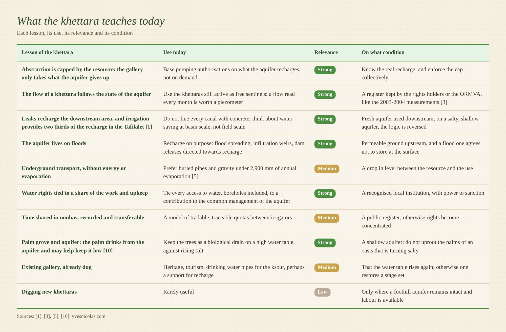
Solar pumping in the Ferkla shows where the line lies [5]. It saves collective access in the short term, but it pumps from the very aquifer the gallery drains. It only becomes a useful lesson if it is capped at the volume the aquifer recharges, that is, if it obeys the rule of the khettara.
11. In Morocco and Spain: what the khettara teaches us, and what must change
One borehole after another
In Morocco, the same story repeats itself with each new pump. The diesel pump reached the Tafilalet in 1965 and, thirty years later, most of the historic khettaras were dead [9]. The Haouz lost almost all its galleries in half a century [4, 45]. In the Ferkla, solar pumping grew from about twenty stations in 2013 to more than 180 in 2020, and irrigated extensions more than doubled between 1984 and 2021 [5]. Each time, the technique changes, and the result stays the same: uncapped individual abstraction empties the aquifer that the collective structure used to share. Yet the country has the tools: law 36-15, the prohibition perimeters whose decree was adopted in February 2025 [16], and the participatory groundwater management contracts, launched as early as 2006 in the Souss [18].
In Spain, the heritage is shared, and so is the failure. The qanat was known there from 753-754 [12], and Madrid was supplied from the 17th to the 19th century by viajes de agua built on the qanat model, whose Muslim origin is still debated [13, 31]. Spain is going through the same drift as Morocco: according to WWF, one aquifer in four is overexploited there, and an estimate cited by the same organisation counts more than half a million illegal wells in the country [19]. In June 2021, the Court of Justice of the European Union ruled against Spain for breaches of the Water Framework Directive and the Habitats Directive around Doñana, notably for failing to take illegal abstraction into account in its balances [20].
But Spain has also provided the counter-proof. At Doñana, when the Guadalquivir river basin authority stopped abstraction on the Los Mimbrales estate, which it had bought, in 2016, the water table, on alert in 2014 and 2015, kept rising until it returned to normal [21]. Stopping boreholes makes an aquifer rise again, and fast. This is the lesson of the khettara, measured in the field.
And Spain has reinvented the khettara institution through law. Since the 1985 law, groundwater there is public, although earlier private wells could be kept, entered either in the water register for fifty years from 1986, or in the catalogue of private waters, closed in 2001 [22, 43]. Users of an aquifer declared at risk must, at the request of the basin authority, form a users' community, responsible for monitoring abstraction, installing meters and reporting irregularities [22]. A 2024 order requires meters with remote transmission, with deadlines running from November 2025 to November 2028, and up to 2029 for the smallest irrigators [22]. A group of users of the same aquifer, responsible for measuring and sharing it: this is the jmaa of the khettara, written into modern law.
What must change in Morocco
First, count every abstraction. A meter on every agricultural borehole, read and published aquifer by aquifer, on the model of the Spanish remote-reading meters. The flows of the khettaras still active, read every month, become the public indicator of the state of each oasis aquifer.
Next, ban the boreholes that threaten existing structures. Classify as a prohibition perimeter the supply zone of each active khettara, under articles 111 to 113 of law 36-15 [16], and close unauthorised stations: the gap between 200 authorised and 415 in operation in the Ferkla shows where the problem begins [5].
Cap the irrigated area as well. Make any support for pumping, solar included, conditional on a ceiling of area and volume, otherwise the water saved goes to irrigate new extensions.
Recharge the aquifer. Direct a share of dam releases and floods towards infiltration upstream of the palm groves, since the Tafilalet aquifer lives on floods [1].
Finally, entrust the aquifer to its users, with real powers. Give aquifer contracts the strength of the Spanish users' communities, and build them on the institutions that already exist: the jmaa, the sheikh of the khettara, the rights holders. Without bringing back the old hierarchy: khettara water rights were inherited and unequal, cleaning rested on the labour of the haratin, and for many families without rights the borehole opened an access to water they did not have. An aquifer community must therefore open its rights to all real users, boreholes included, in exchange for their share of measuring and control.
What must change in Spain
First, apply its own law. Close illegal wells, as the Guadalquivir authority did for 77 wells at Lucena del Puerto in 2019-2020 [21], rather than regularising land irrigated without rights.
Next, protect the galleries that remain. Inventory the galerías, minas and qanats still holding water, protect them as heritage and read their flow as a witness of the aquifers.
Finally, make users' communities guardians rather than lobbies. Their control role, provided for by law, only makes sense if the allocated volumes stay below the measured recharge.
12. In France: what the khettara teaches us, and what must change
Galleries beneath our towns
France had its draining galleries. Under the hills of Fourvière and the Croix-Rousse, in Lyon, catchment galleries supplied the city from at least the 1st century until the 19th century; they collected springs or seepage at the top of a clay layer, and together could deliver several thousand cubic metres a day [23]. In Provence, galleries dug to tap groundwater are called “mines d'eau”, water mines, at Riez, Valensole, Artignosc or around Aix [24]. The khettara principle is therefore not exotic: it sleeps beneath our towns and hillsides, often forgotten.
France has already written the rules of the khettara. Since the 1992 water law, every groundwater abstraction structure, even a domestic one, must have appropriate means of measurement; in water distribution zones, in chronic deficit, any abstraction with a capacity of at least 8 m³/h requires authorisation and, below that, a declaration; elsewhere, the thresholds are based on annual volume, 10,000 m³ for declaration and 200,000 m³ for authorisation [25, 44]. Since 2009, every domestic well or borehole must be declared at the town hall, and under the mining code if it is deeper than 10 m [26]. In basins with an agricultural deficit, a single collective management body shares out each year the volume that may be abstracted among the irrigators, under the supervision of the prefect [26]. Measuring, sharing a finite volume among rights holders, within a responsible group: khettara society did nothing else.
But knowledge of the flow remains incomplete. The Water Plan of March 2023 aims for 10 % less abstraction by 2030 compared with 2019 [27], and points out that abstraction will have to be measured in order to reduce it to the level the resource can bear [28]. Thirty years after metering became compulsory, measurement is therefore still a goal. I know of no reliable figure on the share of domestic boreholes actually declared, which is in itself an indicator of what is missing.
What must change in France
First, base the volume that may be abstracted on measured recharge. The khettara can only take what the aquifer gives up; the volume shared out by the collective management bodies should obey the same physical limit, and not the demand of users.
Then make measurement real and public. Meters actually installed and read on all boreholes, domestic ones included, with data published aquifer by aquifer.
Also turn old galleries and springs into sentinels. The flow of a water mine or a tapped spring tells the state of the aquifer, for free; they should be inventoried, protected and monitored.
Likewise, protect existing structures against new boreholes. On the model of the harîm, and of the protection perimeters of drinking water catchments, ban boreholes that would draw down the aquifer of a spring, a gallery or a communal catchment on which a whole village depends.
Finally, recharge rather than pour concrete. Keep earthen the gravity canals that feed the accompanying aquifers, and let rainwater seep in where it falls, instead of draining it away.
France already provides for what the khettara did by habit: measuring, sharing a finite volume, holding a group responsible for its sharing. What is missing are meters actually installed and published readings.
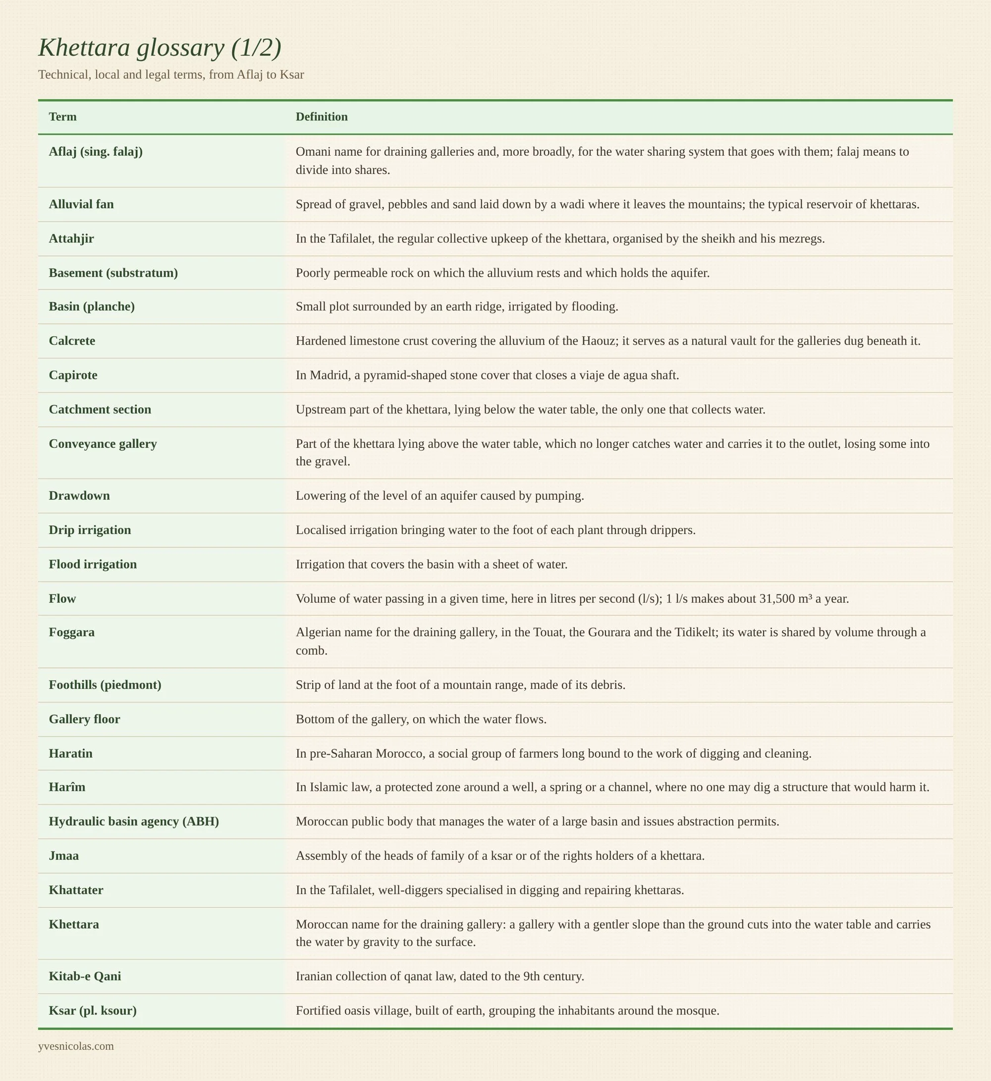
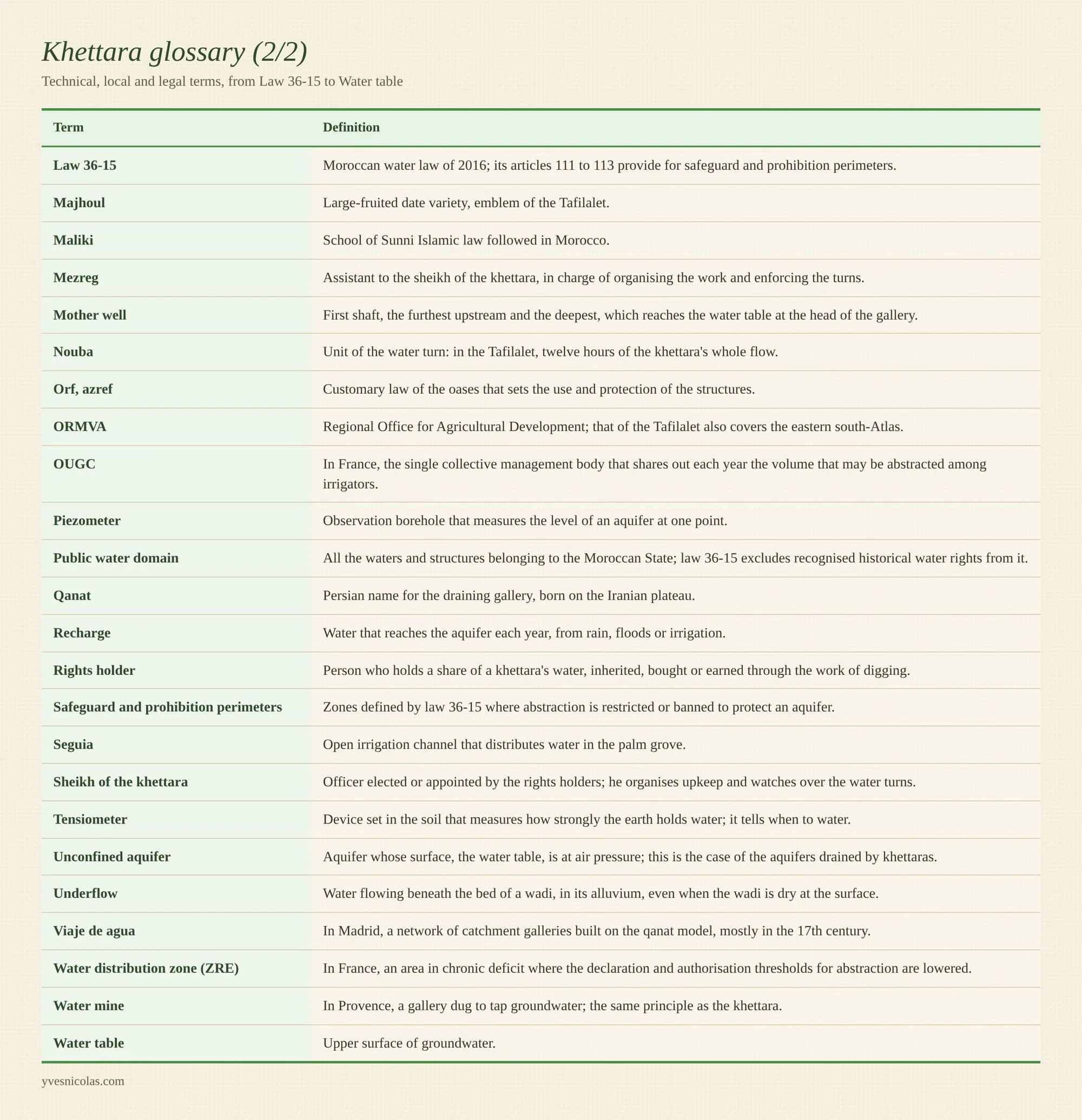
Glossary
The technical, local and legal terms used in the article, in alphabetical order.
References
Sources accessed on 29 October 2026.
1. Margat J., 1961. Hydrogéologie de la plaine du Tafilalt (Maroc pré-saharien). La Houille Blanche, n° spécial B.
2. JICA et ORMVA du Tafilalet, 2005. Annexe B, Réhabilitation des khettaras, étude du projet de développement des communautés rurales à travers la réhabilitation des khettaras.
3. JICA et ORMVA du Tafilalet, 2005. Tableaux par secteur et suivi des débits 2003-2004.
4. JICA et ORMVA du Tafilalet, 2005. Rapport final, chapitre 1, introduction.
5. Khardi Y., Lacombe G., Kuper M., Taky A., Bouarfa S., Hammani A., 2023. Pomper ou disparaître : le dilemme du renforcement des khettaras par le pompage solaire dans les oasis du Maroc. Cahiers Agricultures 32, 1.
6. Ait El Mekki O., Laftouhi N.-E., Hanich L., 2017. Estimate of regional groundwater recharge rate in the Central Haouz Plain, Morocco, using the chloride mass balance method and a GIS. Applied Water Science 7(4), 1679-1688.
7. Nahid A., El Mandour A., Juilleret J. Morphological typology of khettaras (Haouz plain of Marrakech, Morocco).
8. Ourahou M., ORMVA du Tafilalet, 1998. Étude khettara Tafilalet, Errachidia.
9. Lightfoot D. R., 1996. Moroccan khettara: traditional irrigation and progressive desiccation. Geoforum 27(2), 261-273.
10. El Khoumsi W., Hammani A., Bouarfa S., Bouaziz A., Ben Aissa I., 2017. Contribution de la nappe phréatique à l’alimentation hydrique du palmier dattier dans les zones oasiennes. Cahiers Agricultures 26, 45005.
11. Sabri A., Bouaziz A., Hammani A., Kuper M., Douaik A., Badraoui M., 2017. Effet de l’irrigation déficitaire contrôlée sur la croissance et le développement foliaire du palmier dattier. Cahiers Agricultures 26, 55005.
12. Barceló M., 1983. « Qanat(s) » a al-Andalus. Documents d’anàlisi geogràfica, Universitat Autònoma de Barcelona.
13. Fernández-Tapia E. J., Bermúdez-González J. L., Barrera-Vera J. A., Carretero-Ayuso M. J., 2024. New perspectives in the investigation of qanats in the central area of the Iberian Peninsula. Water History 16, 21-43.
14. Beraaouz M., Abioui M., Hssaisoune M., Martínez-Frías J., 2022. Khettaras in the Tafilalet oasis (Morocco): contribution to the promotion of tourism and sustainable development. Built Heritage 6, 24.
15. Turkiye Diyanet Vakfı. Harîm, TURKİYE DİYANET VAKFI İslam Ansiklopedisi.
16. Royaume du Maroc. Travaux du Conseil de gouvernement du jeudi 6 février 2025, décrets n° 2.25.61 et 2.25.62 pris en application de la loi 36-15.
17. Loi n° 36-15 du 10 août 2016 relative à l’eau, fiche UNEP LEAP.
18. Contrats de gestion participative des eaux souterraines au MarocOuassissou R., Kuper M., Dugué P. et al., 2019. Rivalités et arrangements collectifs pour l’accès à l’eau souterraine au Maroc. Cahiers Agricultures 28, 4 ; et Closas A., Villholth K. G., 2016. Aquifer contracts: a means to solving groundwater over-exploitation in Morocco? IWMI.
19. Pallarés E., 2023. Article sur la proposition de loi d’irrigation de Doñana, chiffres du WWF. La Marea, 12 avril 2023.
20. La Commission européenne ouvre une procédure contre l’Espagne pour non-exécution de l’arrêt Doñana. The Diplomat in Spain, juillet 2022 (arrêt CJUE C-559/19 du 24 juin 2021).
21. WWF Espagne, 2020. Informe del estado del acuífero de Doñana, juillet 2020.
22. García Carretero M., 2024. Derechos en el uso del agua : estructura y horizonte temporal de las aguas subterráneas.
23. Bernot E., 2023. Alimenter la ville de Lyon en eau : les galeries de captage antiques sous les collines de Fourvière et de la Croix-Rousse. Gallia 80(1), 407-420.
24. Muséum d’histoire naturelle d’Aix-en-Provence, 2026. Les mines d’eau dans le Verdon et la région aixoise.
25. Sénat, 2008. Réponse ministérielle à la question n° 03464 sur le comptage des prélèvements, JO du 18 septembre 2008.
26. Chambre d’agriculture de Bourgogne-Franche-Comté, 2022. Fiche forage, retenue et irrigation.
27. Banque des Territoires, 2023. Plan Eau : Emmanuel Macron veut conforter le rôle des élus locaux.
28. Banque des Territoires, 2023. Les principales mesures du Plan Eau intéressant les collectivités.
29. El Mandour A. Moroccan khettaras : the system of khettaras in Morocco, from the 10th century to the present day. Global Network of Water Museums (UNESCO-PHI).
30. Liebenberg P. J., Zaid A. Date palm irrigation. FAO, Date Production Support Programme.
31. Ayuntamiento de Madrid. Historia del viaje de agua de Amaniel.
32. El Ouali A., Roubil A., Lahrach A. et al., 2024. Assessments of groundwater recharge process and residence time using hydrochemical and isotopic tracers under arid climate: insights from Errachidia basin (Central-East Morocco). Groundwater for Sustainable Development 25.
33. Médias24, 21 septembre 2024. Pourquoi la région de Tata est si exposée aux risques d’inondations.
34. TelQuel, 12 mars 2025. À Tafilalet, les oasis reprennent vie après les pluies salvatrices.
35. Khardi Y., Lacombe G., Dewandel B., Hammani A., Taky A., Bouarfa S., 2024. Conjunctive use of floodwater harvesting for managed aquifer recharge and irrigation on a date farm in Morocco. Irrigation and Drainage 73(4), 1424-1436.
36. Zein Taleb Z., Khardi Y., Lacombe G. et al., 2024. Prendre soin de la nappe : quelles possibilités et quelles prédispositions des collectifs d’agriculteurs des oasis de Todgha Ferkla (Maroc) à installer des dispositifs de recharge de la nappe ? Alternatives Rurales, hors-série Oasis.
37. ICOMOS, 2006. Évaluation n° 1207, The aflaj irrigation systems of Oman. UNESCO, Centre du patrimoine mondial.
38. Sultanat d’Oman, décret royal 39/2017 sur la gouvernance et la protection des sites d’aflaj inscrits au patrimoine mondial ; Oman Observer, interdiction des nouveaux puits près des aflaj.
39. Cressey G. B., 1958. Qanats, karez and foggaras. Geographical Review 48(1).
40. Qanat’s hydraulic harim determination by the usage of meshless numerical methodMohtashami A., Al-Ghafri A. S., Akbarpour A., 2023. Qanat’s hydraulic harim determination using the meshless numerical method. Journal of Hydroinformatics 25(3), 1103-1120.
41. Mirzaei A., Theesfeld I., 2025. Diving deep into legal layers: institutional grammar’s insight into Iran’s groundwater laws. Water Policy 27(4), 477-500.
42. décret n° 2-17-596 du 10 octobre 2017Royaume du Maroc, portant délimitation du périmètre de sauvegarde de Chtouka et déclarant l’état de pénurie d’eau à l’intérieur de ce périmètre. FAOLEX.
43. Ministerio para la Transición Ecológica, Aprovechamientos de aguas anteriores a la Ley de Aguas 29/1985.
44. Code de l’environnement, article R.214-1, nomenclature des installations, ouvrages, travaux et activités, rubriques 1.1.2.0 et 1.3.1.0 ; tableau détaillé de la DRIEAT Île-de-France, mars 2024.
45. IRD. La gestion des galeries drainantes (khettaras) au Maroc, citant Pascon 1983 et El Faiz 2002. Documentation IRD Horizon.
46. Community-based archaeological survey of the khettara oases along the Jebel Bani, 2024. Journal of Community Archaeology and Heritage.
47. Direction de l’aménagement du territoire et PNUD, 2016. Programme Oasis Tafilalet 2006-2016, document de synthèse : restauration des khettaras Omaria (2011) et Litama (2013), Route du Majhoul.
48. Ourahou M., ORMVA du Tafilalet. Étude de sauvegarde des khettaras dans le Tafilalet, cas de la zone Fezna-Jorf-Hannabou. Note de synthèse, vers 2002-2003, mise en ligne par l’auteur sur SlideShare.